|
The charters help you learn the territory, they expand your
knowledge of the visual waypoints you are encountering so
you will know where to make your turns, ascents and descents.
Also, it is easy  to
set a GPS and fly to a waypoint for a lake or a cabin, but
what do you do when the weather is not ideal? (You will see,
when you download the weather from the internet to make your
flight more realistic, that 8 out of 10 times, you are at
minimal VFR conditions). But you have people vacationing out
in the forest in the cabins that need to be picked up "on
Monday" and other visitors who will take their place
"on Monday." If you wait for the blue skies, you
will have some starving people out in the wilderness and a
long line of people in your waiting room drinking your free
coffee! Ceilings of 2000 feet are typical ... but the mountains
range from 2000 to 7500 feet. You may easily get above the
clouds and fly to a GPS waypoint, but where are you going
to come down through such a ceiling with hundreds of rocky
peaks below you? The only way to solve this problems is fly
treetop, above the flat and [mostly] predictable surface of
the water. This means the route you take may not be direct
at all, but will be winding through the maze of mountains
and fjords. None of these have electronic waypoints ... you
must learn to recognize them, visually. The charters teach
you how to do this. to
set a GPS and fly to a waypoint for a lake or a cabin, but
what do you do when the weather is not ideal? (You will see,
when you download the weather from the internet to make your
flight more realistic, that 8 out of 10 times, you are at
minimal VFR conditions). But you have people vacationing out
in the forest in the cabins that need to be picked up "on
Monday" and other visitors who will take their place
"on Monday." If you wait for the blue skies, you
will have some starving people out in the wilderness and a
long line of people in your waiting room drinking your free
coffee! Ceilings of 2000 feet are typical ... but the mountains
range from 2000 to 7500 feet. You may easily get above the
clouds and fly to a GPS waypoint, but where are you going
to come down through such a ceiling with hundreds of rocky
peaks below you? The only way to solve this problems is fly
treetop, above the flat and [mostly] predictable surface of
the water. This means the route you take may not be direct
at all, but will be winding through the maze of mountains
and fjords. None of these have electronic waypoints ... you
must learn to recognize them, visually. The charters teach
you how to do this.
Using the Charters
You can read through the charters on the web, and when you
decide upon one that you want to fly, you can just go to the
"Printer Friendly" file and it will download for
you quickly for that particular charter. Print it out and
you are on your way. Also, you can "enlarge" the
map for printing two ways, by clicking on the Enlarge Map
[here] or by just clicking on the map itself. It is suggested
you print that also as it will be a handy reference for you
while flying.
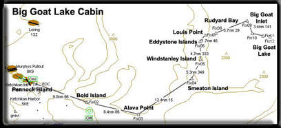
Using the TripTix
Imagine you are a bush pilot sitting in your Ketchikan area
office, you decide to make your own TripTix (trip tickets)
so you can remember how to get to a particular location. You
grab a pad of Misty Moorings, Inc paper, sit down to the typewriter
and type out the directions so you can go find the place some
other time ... or so another pilot can could find the location.
You stuff these into the map box on the plane so the next
time someone needs to go to a particular location, all you
have to do is dig it out of the map box and scotch tape it
to the windshield.
The Purpose of the TripTix is to help people quickly find
a particular addon scenery using TreeTop VFR planning and
directions. All of these are created for low level flight
for unfavorable, but must-fly weather. Not as informative
as the Charters, but they will "get you there" the
first time safely. Print them out and scotch tape them to
the panel and follow your way along. These too are designed
to help the virtual pilot "learn" the area as landmarks
are pointed out along the way for the pilot. (TripTix is "plural"
... but you will also see TripTic which is singular ... meaning
"Trip Ticket."
Software Helpers for the Charters
There are helpers that we have added for the novice bush
pilots. If you have FSNavigator, routes have been created
for all the charters. The routes can be downloaded from within
the charter package. These plans will fly you through even
the most treacherous areas and get you through safely. Also,
for the Misty Fjords area, there is an EZ-Landmark database,
with over 400 waypoints made especially for Misty Fjords,
that can be downloaded and used with the EZ-Landmark program
(see below). This database can be downloaded from the table
at the top of this page. With the [shift F11] stroke you can
make these waypoint names appear and disappear. You do not
need these programs to fly these charters, you can fly them
purely VFR. All the headings are listed for you.
- FSNavigator
- FSNavigator is a fully integrated plug-in for FS2004,
FS2002, FS2000, and FS98. The program is activated with
the F9 key. Pressing this key makes Flight Simulator
change its face to become FSNavigator. At the same time
all Flight Simulator functions continue normally. The
Menu and all FS keys remain active. In the alternative
display mode FSNavigator is a separate window, that
can be positioned freely anywhere in the Flight Simulator
Window. For display of the world map FSNavigator uses
your own Flight Simulator scenery. Addon scenery which
has been added to your scenery library in FS, is also
displayed on the world map. FSNavigator can be used
in full in a trial period of 20 Flight Simulator sessions.
After this the world map will be empty. If after the
20 free sessions you want to use the program without
restrictions then a registration key is necessary. [click
here] You can also purchase this program from SimFlight
[here].
- When you download the "plans" from the zip
files in the various charters you will find files with
the suffix ".fsn" and these are the FSNavigator
plan files. These should be placed in:
Flight Simulator 9/Modules/FSNavigator/Plans/*.fsn
- Once you have placed them in the folder, you can load
them. INSIDE FSNavigator go to the 'open file' (at the
top, 2nd icon from the left in the second row) click
it and select the plan you want.
- Note: don't try to use these plans using an F-18 (unless
you have crash "turned off!").
Pilot's Note: In the FSNav Options menu there
is a menu item called Settings. If you select the
FMS tab and Mode 2 and make the following changes
you will have control of your aircraft.
1. The HDG scroll down to set Heading. This will cause
FSNav to set the Heading Bug on the gyro but not set
the auto pilot heading. You can make it set the heading
with CTRL H, then the autopilot will follow the flightplan
in FSNav.
2. The ALT scroll down to Set Manually. This will
allow you to set the altitude to whatever you want
with CTRO Z. (You will use this often for Treetop
Flying in these charters).
Leave the rest of the settings at the default. Click
OK. Then on FMS set FSNav to M2, unless you want it
to fly the flightplan for you. Autopilot is unnecessary
unless you step away or are typing in the chat window.
Once you have set to a heading or altitude disable
them at will with CTRL H or CTRL ZZ don't turn off
the autopilot with Z as this will also kick FSNav
out of flying the Flightplan. (see note 4)
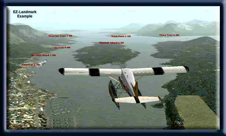
- EZ-Landmarks
- While flying in the simulator, do you peer out the window
towards the ground below and wonder what you're looking
at? What is that mountain, this inlet's name or that river
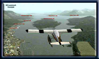 basin or glacier? EZ-Landmark is like having your own
private tour guide. The idea behind this ingenious software
is simple: display the name of the landmark for you. The
program includes more than 170,000 600,000+ sites and
other databases for the world as well. Misty Moorings,
Inc. adds one more database for you. The latest database
is available by clicking on the picture below. This database
will name the glaciers, mountains and key waypoints in
Misty Fjords. We continually update the database as we
add sceneries and as we too learn more about the area.
(And if we miss a landmark you think should be there,
contact
us and we'll put it in for you. Then you can download
it later and your waypoint will be there. Watch for the
latest date on it.
basin or glacier? EZ-Landmark is like having your own
private tour guide. The idea behind this ingenious software
is simple: display the name of the landmark for you. The
program includes more than 170,000 600,000+ sites and
other databases for the world as well. Misty Moorings,
Inc. adds one more database for you. The latest database
is available by clicking on the picture below. This database
will name the glaciers, mountains and key waypoints in
Misty Fjords. We continually update the database as we
add sceneries and as we too learn more about the area.
(And if we miss a landmark you think should be there,
contact
us and we'll put it in for you. Then you can download
it later and your waypoint will be there. Watch for the
latest date on it.
- You can find this base software package at the SimFlight
site. They also have a "try before you buy"
option that allows you to download and try the program
from Abacus. [click
here]
- To view the landmark labels, you press [Shift F11] and
press it again and they disappear. The Misty Fjords database
has about 400 new waypoints in it that cover the entire
flying area of the Misty Fjords scenery package.
- First, you must install EZ-Landmarks. To install the
database, download it from the table above. Unzip the
file and place it in:
Flight Simulator 9/EZ-Landmarks/
- Turn on the flight simulator and under the options for
EZ-Landmark's dropdown, put a check in the "Misty
Fjords" box. Your new database is now active. Check
often with this website to make sure you always have the
updated version, we continually add to it as new scenery
addons are created.
- EZ-Landmark may be purchased from Abacus [here].
- The best database for both Misty Fjords and Tongass
Wild is the "full alaska/hawaii" GNIS database.
To get this latest database set, click here:
AbacusEZ-LandmarkGNISDatabases.exe
Click on the picture below for the latest
Misty Fjords Database (Aug 2006)

Flight Simulator 9
Flight Planner Files (.pln)
- Often these files will not be available for these charters.
These only work when you are flying from and airport to
an airport. Our charters may start from an airport such
as Ketchikan Int'l PAKT, but you are flying to a cabin
or a glacier, not another airport. So such plans do not
work for most of these flights. (But that's why we fly
VFR and not IFR in Misty Fjords!). But don't let this
stop you ... treetop VFR is not about autopilots and electronics
... it is about eyesight, knowledge of the area and sometimes
courage.
- If the plan is available, then it must be carefully
placed in your FS9 file. This can be typically found at:
C:\ Documents and Settings\[your name]\My Documents\Flight
Simulator Files\. An easy way to find your file is to
do a SEARCH for *.pln and you will see where your FS9
plans are being stored. Place .pln files in that same
location.
- Briefings for the Kneeboard
- The Charters will have briefings that you can bring
up from the kneeboard (F10). These will be set up to give
you VFR directions in BOLD type and historical, geographical,
general narrative in italic type. If you take a ride in
a bush plane around Ketchikan, you'll find your pilot
not only knows how to fly, he or she usually also knows
how to TALK! They love to tell stories about the area
and point out sights out the window as the beautiful world
of Misty Fjords goes by. The charters are meant not only
to get you from point A to point B, they are also intended
to give you information on the Misty Fjords National Monument
and the people that live and work there. You can download
the briefings from the table at the top of the charter
pages.
|