|
Route Notes:
- Minimum altitude: 1250 feet (for crest of Betton Isld).
- Direct Routing: If the weather is favorable, you may fly a heading
from Higgins Point of 005 for 56 miles.
- Landing zone: Water and grass runway, water can freeze in the
winter
- Scenery needed: Blue Lake Pullout from Misty Moorings, Inc.
- Click [here] for printer-friendly
TripTic
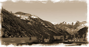
Blue Lake
Blue Lake Pullout has a small grass field and seaplane pullout.
It is a station situated in 'Grandiose' Misty Fjords up above Burrough's
Bay on the north loop of the Behm Canal.
TreeTop VFR Plan
From: Ketchikan International
To: Blue Lake Pullout
1. Fly a heading of about 295 northwest up the center of the
Tongass Narrows.
... you will see ward cove off starboard, with the paper mill
... the furthest point of land to your right is Higgins Point
... Higgins Point is at the end of the Tongass Narrows ... fly toward
it.
2. Round the point to the right at Higgins Point set a heading
of about 330 heading for the high hill on Betton Island, 2 miles
ahead. Your next VFR waypoint is Bushy Point, 14 miles at a heading
of 348.
... You are now flying into the Behm Canal, the waterway circling
Ketchikan
... fly over the tall hill on Betton Island set a heading of 343
for Francis Point (minimum altitude 1250 feet).
...Indian Point is the point coming up 5 miles away at about 2 o'clock.
Loring Bay is the bay just before Indian Point.
... You will be flying up the relative center of the Behm Canal.
... When Indian Point is at 3 o'clock, Francis Point will be at
9 o'clock.
... Traiter's Cove is 5 miles at 2 o'clock when you pass Indian
Point.
... Bushy Point is the next point of land from starboard after Traiter's
Cove. Fly just off shore from Bushy Point.
3. Beside Bushy Point, set a heading to fly about 1/2 mile to
the left of Chin Point, on your way to Brow Point ... it is at a
heading of 340 for 6 miles.
... When you see the large Neets Bay come up to starboard, you know
you are nearing Chin Point, the next point ahead (about 3 miles)
coming from the starboard side of the canal.
... Fly to the left (port) side of Chin Point.
... as you approach Chin Point, the point coming from the port shore
is Snail Point, and Spacious Bay is beyond it.
... follow the shoreline to Brow Point (the final point of land
before the canal opens to starboard).
3. As you pass Brow Point, set a heading of 347 for the shoreline
about 5 miles ahead, as you approach the shoreline,you will be turning
to starboard into the Bell Arm.
... you will cross over the small Gedney Island and you will see
Hassler Island (larger) just beyond it. Plan your heading to fly
around Hassler Island to starboard, this will put you in the Bell
Arm.
... you will see the inlet to the narrow Yes Bay off your port wing.
4. As you turn into the Bell arm, you heading should come to
about 024. The Bell Arm is ahead of you, you will be turing to starboard
to go to the starboard side of Bell Island.
... Follow the curve to starboard of the Bell arm.
... As you approach Bell Island, come to 072 for 3 miles to enter
the Behm Narrows. Bell Island should be coming up now to port.
5. Follow the Behm Narrows on an approximate heading of 039
to Burroughs Bay.
... One waypoint to watch for is Claude Point, "almost"
an island on the starboard side of the canal. Stay in the center
of the canal, Burroughs Bay is straight ahead.
... the Behm Canal will turn off to starboard, you will go straight
into Burroughs Bay.
6. As you Enter Burroughs Bay, continue to fly straight ahead
until you almost reach the shoreline, then turn to port to a heading
of 016 (you will see the Behm Canal going off 90 degrees to starboard).
... Fly to the end of Burroughs Bay where you will find the
Unuk River emptying into the Bay.
... You will follow this river basin for 15 miles, slowly curving
to port continuing on an approximate 016 heading.
... first you will fly over the many Willow Islands formed by the
rivers many channels at this point.
... Eventually, you will make a slight correction to port to continue
up the river basin.
... Follow this until you find it forks to the left and right.
7. At the fork in the river basin, you will be taking the left
fork which is the Blue River. This river will lead you to Blue Lake.
... Prepare to curve to the left to follow the Blue River.
... Prepare to land, Blue Lake will be around the river bend to
port just ahead. Once you make the turn, you will see Blue Lake,
the runway is on this side of the lake.
... stay to the left, over the river as it comes out of the lake,
the runway will be on a 30 degree angle to your right.
===============================================================
To return direct to Higgins Point,fly back down the river basin
gaining 3500 feet in altitude so that when you are over the Behm
Canal, you can fly direct to Higgins point on a heading of 191 for
35 miles.
Doug Linn
Charter Manager
Misty Moorings, Inc
contact@mistymoorings.com
|