|
[Return to
Charter Page]
A VFR Flight Package
Misty Fjords - 'The Cabins' Charter
(Misty Fjords Scenery -
Servicing the US Forestry Service Cabins)
|
Location of Flight
|
Base: Ketchikan, Alaska |
|
Creation Date
|
October 2004 |
|
Estimated Distance
|
Varies by cabin selected (15-50 Miles) |
|
Estimated Time in Route
|
Varies by cabin selected ( 20 min to 1.2 hours) |
| Scenery Download |
Misty Fjords Scenery Package (Payware) |
| Flight Plans
(maps) |
Available in each cabin section, map specific for cabin
selected |
FsNavigator4 Route
Plans |
Winzip
file of all "TO" and "FROM" fsn files |
EZ-Landmark -
Misty Fjords |
Latest
EZ-Landmark Misty Fjords Database (Freeware) |
| Briefing for
The Cabins |
CabinsBriefings.zip |
| Recommended
Aircraft |
Float plane or Amphibian
(Ski if frozen lake) |
| Pilot/Author |
Doug Linn |
| |
Airfield |
ICAO Code |
Runway |
| Departure |
Ketchikan, AK |
PAKT or 5KE |
At Ramp or Water Runway |
| Arrival |
Cabin that is selected |
(none) |
near cabin |

|
Comments on Package
Note: This charter
package has been made exclusively to support the new Misty
Fjords Scenery (payware) package. It is NOT recommended
you fly these charters unless you have this package. The
directions, headings and FSNavigator plans are exact for
the Misty Fjords Scenery package which is more exact than
the standard scenery packages for FS2004.
When you take your first
trip to Alaska, you will have an opportunity to observe
the bush planes, amphibians, helicopters and float planes,
in action. One of the tasks of the bush pilots in this
area is to service the US Forestry Service Cabins that
are sprinkled throughout the Misty Fjords National Monument.
This adventure package will be a little different than
the other charter packages that can be found at Misty
Moorings, Inc. because this package is dedicated to
helping you find the cabins, even in difficult weather
(treetop flying!). When you fly to the cabins, you will
be taking on passengers and supplies ... but those will
be determined by you. This package gets you there and back
safely.
Flying Direct and Treetop
VFR: If you are lucky enough to have a clear weather
day, you may use the "Direct" headings to and
from the cabins. These are set up for Mountain Point
as the start point (the point on the eastern side of
the south end of the Tongass Narrows). This allows you
to have sufficient altitude to commit to any heading
from that point. About 3500 feet is a safe altitude across
[most] of the Misty Fjords National Monument. However,
the flying in this charter package is set up with VFR
in mind, without the need for "electronic" waypoints.
This means you will have to acquire a knowledge for the
area, know what you are seeing and know how to reach
your destination especially under "misty" weather
conditions. We always recommend you download the latest
weather from the internet so you can make your charters
as 'real as it gets.' Do not be surprised that 8 out
of 10 downloads will give you weather that is nearly
unsuitable for VFR flying. That is why they call this
area of the world 'Misty Fjords.' Without electronic
waypoints, you are going to be flying under the low weather
ceilings and navigating by the visual waypoints you encounter,
often between mountains. A wrong turn can put you down
an inlet where there is no outlet and you'll find yourself
looking at the face of a mountain coming at you at 100
mph. If you do these charters realistically, you will
have some white knuckle moments. And that is the way
it really is.
Flying Aids for the Charters:
FSNavigator4 plan files (.fsn) are included
for TO and FROM the cabins. There is also an EZ-Landmark
database exclusively for Misty Fjords that is available.
You can go to the Misty
Moorings, Inc. website to learn more about these programs
and how to interface them with these charters. Notice there
is also a "briefing" available for these flights.
You can download it from the table above. This gives you
instructions to each cabin in the FS2004 briefing window.
Using this Document:
You do not need to read through this entire
document. You may want to start with the section below just
to learn more about the cabins, what it is like to stay at
them, etc. There is an index with hyperlinks that will quickly
position you in this document for the cabin you need. From
each section of the document you will be able to go Back
to Index or Back to Top . Hope you
enjoy the package.
About the Cabins
The following information is directly from the US Forestry
Service website that describes the cabins, how to get to
them, how to rent them and general information on what
to expect if you should have the opportunity (and desire)
to have such an adventure: Please visit their website to
see even more information and background. (See
Note 1)
Reservations: Reservations may be made up to 180
days (6-months) in advance of intended use. Applications will
not be accepted more than 190 days prior to desired occupancy.
Applications received earlier than this will be promptly
returned with an explanation. If more than one application
is is received between 180 and 190 days in advance of intended
use for a cabin for overlapping dates, a drawing will be
held to determine the permittee. Payments will be returned
to unsuccessful applicants. Confirmed reservations may
be made up to 179 days in advance of intended use use on
a first-come, first-served basis. Permittees must be at
least 18 years old. Any number of persons can occupy a
cabin under a single permit. The maximum stay at a cabin
is (7) seven nights between April 1 and October 31, and
(10) ten nights between November 1 and March 31. The advance
payment is refundable upon written request, and return
of the original permit, if it is received in the office
from which the permit was issued from 10 days prior to
intended use. Cabins are reserved from noon to noon. Costs
are from "free" to $25-35 dollars a night. will
not be accepted more than 190 days prior to desired occupancy.
Applications received earlier than this will be promptly
returned with an explanation. If more than one application
is is received between 180 and 190 days in advance of intended
use for a cabin for overlapping dates, a drawing will be
held to determine the permittee. Payments will be returned
to unsuccessful applicants. Confirmed reservations may
be made up to 179 days in advance of intended use use on
a first-come, first-served basis. Permittees must be at
least 18 years old. Any number of persons can occupy a
cabin under a single permit. The maximum stay at a cabin
is (7) seven nights between April 1 and October 31, and
(10) ten nights between November 1 and March 31. The advance
payment is refundable upon written request, and return
of the original permit, if it is received in the office
from which the permit was issued from 10 days prior to
intended use. Cabins are reserved from noon to noon. Costs
are from "free" to $25-35 dollars a night.
Cabin Facilities: The two most common types of
cabins are A-Frames and Pan-Abode. Each can sleep at least
four to six people. A-Frame cabins have an additional second
floor sleeping loft. Each cabin includes tables, benches,
plywood bunks (without mattresses), wood or oil heating/cooking
stoves, ax/maul, broom, and pit toilets.
Water: Water can be taken from nearby streams or
lakes and should be boiled or treated before drinking.
Although many of the rivers and steams appear crystal clear
and give the impression that the water is pure, clarity
is not an indication of the absence of bacteria or parasites.
Whenever surface water is used for drinking or cooking,
it should be treated or boiled for 5 minutes to avoid contracting
giardiasis or other diseases. Giardiasis is an intestinal
disorder which can be contracted from drinking untreated "natural" water.
A pamphlet on drinking water safety, "Is the Water
Safe?" is available from the Forest Service.
Equipment: You must bring your own bedding and
cooking gear. Be sure to check the specific stove information
for the cabin you desire. The Forest Service does not provide
stove oil for cabin users. Oil can be purchased in the
local communities. It MUST be #1 diesel oil for the stove
to operate properly. Oil use varies from 5-10 gallons per
week depending on the time of year and the weather. At
cabins with a wood stove, wood may be provided but must
be split. Check with the Forest Service office administering
the cabin for information on wood availability. An axe
or maul is provided at cabins with a wood stove, but you
should bring a small axe or hatchet just in case the tools
at the cabin are not there. In all cabins it is recommended
that a cooking stove be included in your gear. The wood/oil
stoves do not usually provide sufficient heat for cooking.
 Trail
Information Sheets: At cabins where trail access
is possible or where trails are mentioned; request a
trail information sheet from the Forest Service office
administering the cabin. Trail
Information Sheets: At cabins where trail access
is possible or where trails are mentioned; request a
trail information sheet from the Forest Service office
administering the cabin.
Safety: In the "old-days" thorough preparation
and caution, using simple equipment and common sense, was
a natural part of living and working in the wilderness
of Southeast Alaska. Since then, conditions have changed
little. Safety is still a matter of individual responsibility
and is based on thorough knowledge of what to expect, the
right equipment and common sense. Rain gear, rubber boots
and warm clothing are essential. Extra food and clothing
are recommended, as your stay could be prolonged by bad
weather or poor visibility for travel. In remote locations,
remember you are on your own! We recommend topographical
maps, compass, waterproof matches, strong knife, first-aid
kit, space blanket, small tent or emergency shelter, extra
food, candles, and flares. For those experienced with firearms,
a gun (30.06 or larger caliber) can be taken for unexpected
emergencies.
Bears: Remember that you are in bear country. Burn
trash, or dispose of it so that bears are not attracted.
Keep food items neat and clean to cut down on odors which
may attract bears. Warn bears of your presence by making
noise when in dense cover. "Bear Facts", a pamphlet
on bear safety, is available from the Forest Service.
Shellfish: Clam diggers should be cautious of Paralytic
Shellfish Poisoning (PSP), PSP is an extremely poisonous
toxin found in clams, mussels, geoducks, oysters, snails,
and surface scallops. PSP can kill you--be careful where
you clam. The brochure "PSP What you should know before
you go clamming" is available from the Forest Service.
Pack It In - Pack It Out: Maintenance of Forest
Service cabins is very costly. To reduce these costs and
the possibility of bear and rodent problems, all garbage
and leftover food from your stay MUST be packed out. It
is hoped that you will leave the cabin in the same condition
or better than you found it. Leave a clean cabin so the
next user will also enjoy their stay.
Marine Mooring Buoys: Buoys are strategically placed
to facilitate the anchorage of small boats in interesting
areas otherwise unavailable due to a lack of good anchor "holding
ground". A reservation at a Forest Service cabin does
not include exclusive use of the buoy if one is located
near the cabin. Buoys are on a first-come first-serve basis.
Rafting of more than one vessel is permitted with the agreement
of each vessel owner. Three vessels that are less than
21 feet or two vessels between 21 and 30 feet are allowed
to tie up to an anchor buoy. Do not anchor vessels over
30 feet on mooring buoys. PLEASE limit moorage to 36 hours.
Suggested Items To Take To The Cabin:
Life jackets for cabins with skiffs.
Long shaft boat motor for cabins with skiffs.
First-aid kit, flash light with extra batteries.
Extra food (in case weather conditions prolong your stay).
Portable radio with extra batteries.
#1 diesel fuel for cabins with oil stoves, newspaper
for starting wood stove fires, matches in waterproof
container, candles or lantern.
Sleeping bags, air mattresses, pillows, extra blankets.
Toilet paper, towels, paper towels, garbage bags, buckets
for water and fishing, bar soap, wash cloth, toiletries.
Insect repellent, steel wool (stuff in space under door
to keep critters out).
Portable cooking stove (cabin stove may not produce sufficient
heat for cooking) saucepan with lid for boiling water,
skillet, mixing bowl, can opener, knives, large spoons,
pot holders, aluminum foil, plastic wrap, dish washing
soap, rags, scrubber, plates, bowls, cups, glasses, silverware & coffee
pot.
|
|
|
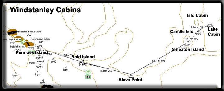
Alava
Bay Cabin (See
Note 4)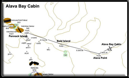
Minimum ceiling: 2000 feet Minimum flyingaltitude: 1700 feet
Minimum visibility: 1 mile
Approximate distance: 20 miles
Landing Area NOT frozen in winter
Water landings year around
FSNavigator files [here]
Enlarged Map [here]
Printer Friendly plan [here]
Direct from Mountain Point to Cabin: 14.5 miles at 081
Direct from Cabin to Mountain Point: 14.5 miles at 260
VFR Directions: To the Cabin
- After leaving PAKT or 5KE, position over Pennock Island in
the Tongass Narrows at a heading of 110
- At the south end of Pennock Island, head toward Bold Island,
Set your heading at 094. Bold Island is 9 miles ahead. [5.4
minutes]
- At the south end of Bold Island, set a heading for 088 for
Alava Point, the point of land 8.3 miles ahead. Begin reducing
altitude as your landing is after the next waypoint.[5 minutes]
- At Alava Point we can set a heading direct for the Alava
Bay Cabin. Set your heading for 024, the cabin is 2.9 miles
ahead [2 minutes].
- You will see three small islands in Alava Bay just ahead.
The cabin is located on the north side of the small island
to the left, nearest the shore. Descend and make approach based
on wind and conditions.
VFR Directions: Returning to Ketchikan
- After leaving the cabin, set a heading for Alava Point, 204
degrees from the cabin, 2.9 miles from the cabin. [2 minutes]
- At Alava Point, set a heading of 269 for Bold Island 8.3
miles ahead. [5 minutes]
- Over Bold Island, set a heading of 275 for Pennock Island
... you are now in the Tongass Narrows and ATC should be directing
your destination, 9 miles. [5.5 minutes]
Description: This is a rustic style 12' x 14' Pan-Abode
log cabin with a wood-burning stove and sleeping 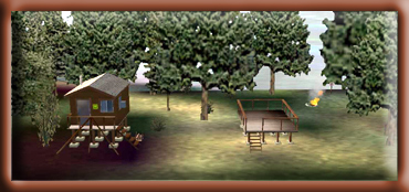 space
for 4 to 6 people. The cabin was constructed in 1974. space
for 4 to 6 people. The cabin was constructed in 1974.
Location: Approximately 20 miles southeast of Ketchikan
on Revillagigedo Island. Located on salt water, it is accessible
by float plane or boat. A mooring buoy is provided. This cabin
is located within the Misty Fiords National Monument Wilderness.
Please Leave No Trace of your visit.
Season of Use: Year-around.
Facilities: 2 single plywood bunks, 2 double plywood
bunks, Table and benches, Wood stove, Cooking counter, Food cupboard
and shelves, Broom, mop and bucket, Outhouse toilet, Axe Maul
and wedge, Mooring buoy
Water is available from a creek near the cabin. Treat
all water before using. Bring your own sleeping bags, sleeping
pads, cooking stove, lantern, pots, pans, plates, utensils, food,
toilet paper, garbage bags, fire extinguisher and fire starter.
This cabin contains a wood stove. Please conserve firewood; supplied
firewood is for wood stove use only. Collect your own beach/driftwood
for campfires.
Additional Comments: There is no skiff provided at this
salt water site. A reservation for a Forest Service cabin does
not include exclusive use of the buoy. Buoy is on a first-come,
first-serve basis; however, mooring of more than one vessel is
allowed, provided the first party there agrees.
Special Features: Welcome to the sunshine cabin. This
cabin offers extensive deck space and warm sunshine early in
the morning on clear days. Saltwater fishing and sightseeing
are the main attractions in this area. Other opportunities exist
for hiking, hunting, and beachcombing. Hunting for sitka blacktail
deer and black bear is popular in this area. In stormy weather
Alava Bay serves as a protected anchorage for small boats.
Back to Index or Back
to Top
|
|
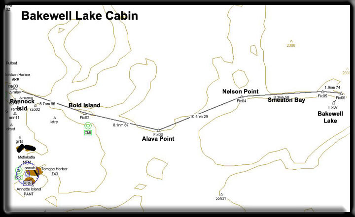
Bakewell Lake
Cabin (See
Note 9)
Minimum ceiling: 2000 feet 
Minimum flying altitude: 1500 feet
Minimum visibility: 1 mile
Approximate distance: 40 miles
FSNavigator files [here]
Enlarged Map [here]
Printer Friendly plan [here]
Direct from Mountain Point to Cabin: 30 miles at 064
Direct from Cabin to Mountain Point: 30 miles at 244
VFR Directions: To Bakewell Cabin
- After leaving PAKT or 5KE, position over Pennock Island in
the Tongass Narrows at a heading of 110
- At the south end of Pennock Island, head toward Bold Island,
Set your heading at 094. Bold Island is 9 miles ahead. [5.5
minutes]
- At the far end of Bold Island, set a heading for 088 for
Alava Point, this is the point of land 8.3 miles ahead. [5
minutes]
- At Alava Point set a heading for Nelson Point 030 which is
11.3 miles ahead up the Behm Canal. [7 minutes]
- At Nelson Point, we set a heading of 057. You are entering
Smeaton Bay.
- At a distance of 7 miles [about 4 minutes] , you will see
the Wilson Arm of Smeaton Bay veering off to port (left). Reduce
altitude to about 1000 feet. The Bakewell Arm is ahead and
to the right. Fly a few degrees to the right to fly into the
Bakewell Arm. Look for a small outcropping in the water just
ahead on the right about 1/4 mile. You will be turning sharply
to starboard (right) just past this outcropping. As you make
the turn, you will see Bakewell Lake ahead of you. The cabin
is almost right under you at this point. Fly on down the lake,
make a safe landing and taxi back to the cabin.
VFR Directions: Returning to Ketchikan
- Taxi down Bakewell lake (about 190 degrees, South) away from
the cabin, once far enough for a takeoff, turn back toward
the cabin (heading about 009) and take off to the north. After
you lift off the lake, be ready to turn sharply to the left
as you enter the Bakewell Arm and follow it back down into
Smeaton Bay.
- Following Smeaton Bay, fly to Nelson Point [5 minutes], which
is the point to the left of Smeaton Bay (this channel). Here
you enter the Behm Canal.
- At Nelson Point, set a heading of 210 for Alava Point 11.3
miles ahead. [7 minutes]
- At Alava Point, set a heading of 267 for Bold Island, 8.1
miles ahead. [5 minutes]
- Over Bold Island, set a heading of 275 for Pennock Island
(8.7 miles) ... you are now in the Tongass Narrows and ATC
should be directing your destination. [5.5 minutes]
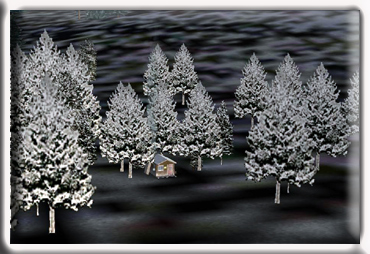 Description:
This is a rustic style 12' x 14' Pan-Abode log cabin with an
oil stove for heat and sleeping space for 4 to 6 people. The
cabin was built in 1978. Description:
This is a rustic style 12' x 14' Pan-Abode log cabin with an
oil stove for heat and sleeping space for 4 to 6 people. The
cabin was built in 1978.
Location: About 40 air miles (64 km) east of Ketchikan
on the mainland south of Bakewell Arm of Smeaton Bay, elevation
168 feet (51 meters). Accessible by float plane or canoe. Access
to the lake from salt water is easy, but the cabin is approximately
two miles down the lake from the end of the trail. Please note:
There is no mooring buoy at the trail head. This cabin is located
within the Misty Fiords National Monument Wilderness. Please
Leave No Trace of your visit.
Season of Use: Year-around.
Facilities: Single plywood bunks, 2 double plywood bunks,
Table and benches, Oil stove (uses #1 fuel oil, NOT provided),
Cooking counter, Food cupboard and shelves, Broom, mop and bucket,
Outhouse toilet, 14' aluminum skiff with oars and NO life jackets
Water is available from a nearby creek or the lake.
Treat all water before using. Bring your own #1 fuel oil for
the oil stove, personal flotation devices, sleeping bags, sleeping
pads, cooking stove, lantern, pots, pans, plates, utensils, food,
toilet paper, garbage bags, fire extinguisher and fire starter.
Special Features: This cabin is ideal for families with
kids or anyone who enjoys lazy days on the beach. The cabin has
a nice white sand beach and lots of room to spread out. It is
surrounded by an old-growth forest of spruce, hemlock, and cedar.
Fishing opportunities include dolly varden and cutthroat trout.
Also, from July through September, sockeye, pink, chum and coho
salmon make their way to the lake to spawn. There is also some
steelhead fishing near the outlet. Always be on the lookout for
other wildlife. You may hear the distant sounds of wolves, see
some Sitka blacktail deer, or witness a beaver or otter swimming
in the lake. Keep your eyes open for eagles, loons and many other
bird species. Hunting occurs in this area.
Back to Index or Back
to Top
|
|
Beaver Camp Cabin (see
note 10)
Minimum ceiling: 2000 feet 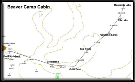
Minimum flying altitude: 1700 feet
Minimum visibility: 1 mile
Approximate distance: 28 miles
FSNavigator files [here]
Enlarged Map [here]
Printer Friendly plan [here]
Direct from Mountain Point to Cabin: 21 miles at 022
Direct from Cabin to Mountain Point: 21 miles at 201
VFR Directions: To the Cabins
- After leaving PAKT or 5KE, position over Pennock Island in
the Tongass Narrows at a heading of 110
- At the south end of Pennock Island, head toward Bold Island,
Set your heading at 094. Bold Island is 9 miles ahead. [5.4
minutes]
- At the south end (far end) of Bold Island, set a heading
for 068 for Cone Point, 3.7 miles ahead. [2 minutes]
- Fly over Cone Island over Cone Point and change heading to
360 heading for Evo Point, distance 5 miles [3 minutes] You
are entering the Thorne Arm. Evo Point is the point of land
sticking out into the water from the left shore.
- At Evo Point, set heading of 006 for Gokachin Lakes, approaching
these lakes, your altitude must be 1700 feet minimum. [2 minutes]
- At Gokachin Lakes, slightly correct heading for 354 and use
this heading to fly to the north end of. Ella Lake. [2 minutes]
Once over Ella Lake, you may reduce your altitude to 1200 feet.
- At the north end of Ella Lake, make a slight heading correction
to 347 and fly through the "dip" between the low
mountain on the left and hill on the right. Follow the grade
at a safe altitude down to Manzanita Lake about 2 miles ahead.
- The Beaver Camp Cabin is at this end (south end) of the lake
on your left. You should land as quickly as you can to avoid
a long taxi.
VFR Directions: Returning to Ketchikan
- After leaving the Beaver Camp Cabin, taxi north on the lake
until you have enough take off room to clear the ridge at the
south of the lake. Begin climbing to 1700 feet. Once over Ella
Lake (about 2 minutes flight time) set a heading of 357 that
will take you to the south end of Ella Lake. [2 minutes]. Continue
your climb to 1700 feet.
- Fly 3 miles to Gokachin Lakes and reset heading for 183 direct
to Cone Point (11.5 miles). [7 minutes]
- At Cone Point, set a heading of 252 for Bold Island, 3.7
miles [2 minutes]
- Over Bold Island, set a heading of 274 for Pennock Island
[5 minutes]... you are now in the Tongass Narrows and ATC should
be directing your destination.
Description: This is a rustic style 12' x 14' Pan-Abode
log cabin with an oil-burning stove for heat, and sleeping space
for 4 to 6 people. The cabin was built in 1965.
Location: About 28 air miles northeast of Ketchikan,
on Revillagigedo Island on the southern arm of Manzanita Lake.
Accessible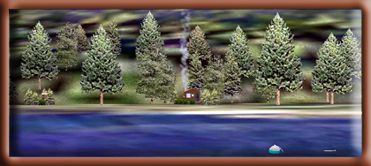 by
float plane. This cabin is located within the Misty Fiords National
Monument Wilderness. Please Leave No Trace of your visit. by
float plane. This cabin is located within the Misty Fiords National
Monument Wilderness. Please Leave No Trace of your visit.
Season of Use: Year-around.
Facilities: 2 single plywood bunks, 2 double plywood
bunks, Table and benches, Oil stove (uses #1 diesel, NOT provided),
Cooking counter, Food cupboard and shelves, Broom, mop and bucket,
Outhouse toilet, 14' aluminum skiff with oars and NO life jackets
Water is available from a nearby creek or the lake. Treat
all water before using. Bring your own stove oil (#1 stove oil
or kerosene only), personal flotation devices, sleeping bags,
sleeping pads, cooking stove, lantern, pots, pans, plates, utensils,
food, toilet paper, garbage bags, fire extinguisher and fire
starter.
Special Features: This cabin is located in a large old-growth
forest of spruce, hemlock, and cedar. This provides lots of opportunities
for people who enjoy this type of setting. From the lake shore
there is a spectacular view of the mountains across the lake.
This lake has one other cabin, Manzanita Lake Cabin, located
on the northwest arm of the lake. Fishing is rated as excellent
for cutthroat, dolly varden, and kokanee (land-locked salmon).
Hunting for Sitka blacktail deer and black bear is popular in
this area. Beaver, mink, and marten are common.
Back to Index or Back
to Top
|
|
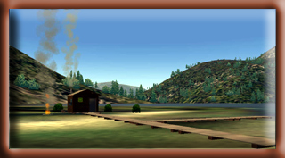
Big Goat Lake Cabin (See
Note 11)
Minimum ceiling: 2500 feet 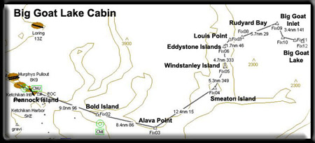
Minimum flying altitude: 2200 feet
Minimum visibility: 3 mile
Approximate distance: 45 miles
FSNavigator files [here]
Enlarged Map [here]
Printer Friendly plan [here]
Direct from Mountain Point to Cabin: 35 miles at 40
Direct from Cabin to Mountain Point: 35 miles at 220
Note: This is a more difficult cabin to approach,
especially in minimum weather conditions. You must have a ceiling
of 2500 feet and you will be flying at 2200 feet altitude as
you approach the cabin. This is a "high lake" cabin,
resting at almost 1756 feet in altitude.
VFR Directions: To the Island Cabin
- After leaving PAKT or 5KE, position over Pennock Island in
the Tongass Narrows at a heading of 110
- At the south end of Pennock Island, head toward Bold Island,
Set your heading at 094. Bold Island is 9 miles ahead. [5.4
minutes]
- At the south end of Bold Island, set a heading for 088 for
Alava Point, the point of land 8.3 miles ahead. [5 minutes]
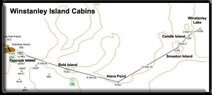
- At Alava Point set your heading at 017 for Smeaton Island,
9.6 miles ahead. You will fly over Rudyerd Island on this leg.
At this point, you are in the Behm Canal, a body of water that
circles the Ketchikan Area. [5.5 minutes]
- At Smeaton Island, set your heading at 002 for Candle Island.
This is the small island at the southern tip of Winstanley
Island [2 minutes]
- Over Winstanley Island, set a heading of 333 for the Eddystone
Islands, a small group of little islands 4.7 miles ahead [3
minutes]
- Over the Eddystone Islands, turn to a heading of 357 to cross
over Louise Point, at the entrance of Rudyerd Bay. [2 minutes]
- At Louise Point, turn into Rudyerd Bay on a heading of 046
... and be ready about 2 miles later to make a slight heading
change to 29 degrees following Rudyerd Bay. You will see Punchbowl
cove leading off to your right, you will ease left and continue
following Rudyerd Bay. [5 minutes] NOTE: Be sure you are at
2200 feet minimum!
- You will see an intersection ... you are going to take the
right fork into Big Goat Inlet on a heading of 141. [3 minutes]
- At the end of Big Goat Inlet you will take a sharp right
turn to a heading of 088. NOTE: Be sure you are at 2200 feet
minimum!
- You will see a mountain wall ahead of you with a waterfall
coming over the top. Fly just to the right of the waterfall,
once over it, you will be looking at Big Goat Lake. The lake
veers a little to the left, make a slight heading correction
and land. Big Goat Lake Cabin is on the second point on your
right.
VFR Directions: Back to Ketchikan ... there are 2 ways you can
go back to Ketchikan
1st Alternative Return: Returning as you arrived, back down
Big Goat Inlet and Rudyerd Bay.
- Taxi to the far end of the lake and head back toward the
cabin, an approximate heading of 254 ... give yourself plenty
of room for takeoff
- Take off, flying over the cabin and once you are clear of
the lake and out over the dropoff, be ready to make a right
turn into Big Goat Inlet, Heading 319 for 3.4 miles [1.5 minutes]
- Be ready to make a sharp turn to the left (heading of 210)
following Rudyerd Bay back to Louis Point, about 8 miles. [5
minutes]
- At Louis Point, set a heading of 177 toward the Eddystone
Islands about 2 miles.
- Over the Eddystone Islands, set a heading of 154 degrees
to fly over Winstanley Island. 5 miles [3 minutes]
- Over Winstanley Island, set a heading of 170 for Smeaton
Island 5 miles ahead. [3 minutes].
- At Smeaton Island, set a course for Alava Point at a heading
of 199, 12.4 miles ahead. [7.5 minutes]
- At Alava Point, set a heading of 269 for Bold Island 8.3
miles ahead. [4.8 minutes]
- Over Bold Island, set a heading of 275 for Pennock Island
[5 minutes] ... you are now in the Tongass Narrows and ATC
should be directing your destination.
2nd Alternative Return: Returning via Wilson Lake
- Set a heading of 077 for takeoff from the cabin.
- As you fly over the edge of the lake, make a right turn to
a heading of 179 taking you over Wilson Lake. Wilson lake is
immediately visible as you make the turn.
- At the south end of the lake, begin following the Wilson
River down to the Thorne Arm of Smeaton Bay, approximately
5 miles. (Approximate heading 150). [3 minutes]
- Turn right into the Wilson Arm and fly an approximate heading
of 187, making a correction about 3 miles later to 240 heading
toward the Behm Canal.
- Fly to Nelson Point, which is the point to the left of Smeaton
Bay (this channel) and here you enter the Behm Canal.
- At Nelson Point, set a heading of 210 for Alava Point 11.3
miles ahead. [7 minutes]
- At Alava Point, set a heading of 267 for Bold Island, 8.1
miles ahead. [5 minutes]
- Over Bold Island, set a heading of 275 for Pennock Island
(8.7 miles) ... you are now in the Tongass Narrows and ATC
should be directing
 your
destination. [5 minutes] your
destination. [5 minutes]
Description: This is a rustic style 12' x 12' Pan-Abode
log cabin with a oil-burning stove (use #1 diesel fuel) and sleeping
space for 4 to 6 people. The cabin was constructed in 1964. This
cabin has been removed from the reservation system due to poor
outhouse and skiff conditions. It is on a first-come first-served
basis now and is free.
Location: About 45 air miles northeast of Ketchikan,
on the mainland east of Rudyerd Bay, elevation 1775 feet (540
meters). Accessible by float plane. In fall, winter and early
spring, the cabin may be inaccessible due to the frozen lake
surface (float planes cannot land). This cabin is located within
the Misty Fiords National Monument Wilderness. Please Leave No
Trace of your visit.
Season of Use: Year-around.
Facilities: 2 single plywood bunks, 2 double plywood
bunks, Table and benches, Oil stove (fuel not provided), Cooking
counter, Food cupboard and shelves, Broom, mop and bucket,Outhouse
toilet
Water is available from the lake. Treat all water before
using. Bring your own fuel oil (#1 diesel) for the oil stove,
sleeping bags, sleeping pads, cooking stove, lantern, pots, pans,
plates, utensils, food, toilet paper, garbage bags, fire extinguisher
and fire starter.
Special Features: This is the most scenic cabin on the
district. This lake cabin is located in a saddle surrounded by
alpine cliffs. This gives numerous opportunities for hiking/exploring,
boating, scenic photography, fishing (grayling were planted in
1965; fishing has been good), and wildlife viewing. Mountain
goats are plentiful in the area surrounding the cabin. Please
note: This cabin is located in the flightseeing flight path with
heavy plane traffic June to September
|
Minimum ceiling: 2000 feet 
Minimum flying altitude: 1500 feet
Minimum visibility: 1 mile
Approximate distance: 45 miles
FSNavigator files [here]
Enlarged Map [here]
Printer Friendly plan [here]
Direct from Mountain Point to Cabin: 27 miles at 039
Direct from Cabin to Mountain Point: 27 miles at 220
VFR Directions: To the Island Cabin
- After leaving PAKT or 5KE, position over Pennock Island
in the Tongass Narrows at a heading of 110
- At the south end of Pennock Island, head toward Bold Island,
Set your heading at 094. Bold Island is 9 miles ahead. [5.4
minutes]
- At the south end of Bold Island, set a heading for 088
for Alava Point, the point of land 8.3 miles ahead. [5 minutes]
- At Alava Point set your heading at 017 for Smeaton Island,
9.6 miles ahead. You will fly over Rudyerd Island on this
leg. At this point, you are in the Behm Canal, a body of
water that circles the Ketchikan Area. [5.7 minutes]
- At Smeaton Island, set your heading at 002 for Candle Island.
This is the small island at the southern tip of Winstanley
Island [3 minutes]
- Continue north over Winstanley Island. Just past the end
of the island, look for Checats Cove on the shoreline to
the right.[2 miles] A small waterfall can be seen emptying
into the cove, fly over the waterfall. Cross Checats Cove
at a heading of 069 at a minimum altitude of 1550 feet.
- The Lake is 2 miles ahead. You will fly over the cabin
as you approach the lake. NOTE: be careful landing on this
lake. You may have to adjust your heading to starboard, and
there are small islands in the center of the lake.
VFR Directions: Returning to Ketchikan
- Taxi to position yourself to the north side of the little
island between the island and the shore. Select a heading
of 268 and take off.
- As you come over the western shore of the lake, ease 10
degrees to port to cross over Checats Cove.
- As you pass over Checats Cove, about 2 miles, turn toward
Winstanley Island, a heading of 353. Winstanley Island is
3.5 miles ahead. [1.5 minutes]
- Over Winstanley Island, set a heading of 349 for Smeaton
Island, 5 miles ahead. [3 minutes]
- At Smeaton Island, set a course for Alava Point at a heading
of 199, 12.4 miles ahead. [7.5 minutes]
- At Alava Point, set a heading of 269 for Bold Island 8.3
miles ahead. [5 minutes]
- Over Bold Island, set a heading of 275 for Pennock Island
[5.5 minutes] ... you are now in the Tongass Narrows and
ATC should be directing your destination.
Description: This is a rustic style 12' x 12' Pan-Abode
log cabin with a wood-burning stove and 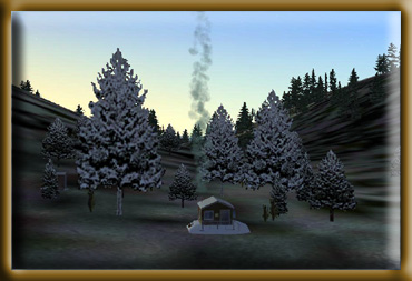 sleeping
space for 4 to 6 people. The cabin was constructed in 1964. sleeping
space for 4 to 6 people. The cabin was constructed in 1964.
Location: Approximately 45 air miles northeast of Ketchikan
on the mainland east of Rudyerd Bay, elevation 710 feet (215
meters). It is accessible by float plane. In fall, winter and
early spring, the cabin may be inaccessible due to the frozen
lake surface (float planes cannot land). This cabin is located
within the Misty Fiords National Monument Wilderness. Please
Leave No Trace of your visit.
Season of Use: Year-around.
Facilities: 2 single plywood bunks, 2
double plywood bunks, Table and benches, Wood stove, Cooking
counter, Food cupboard and shelves, Broom, mop and bucket, Outhouse
toilet,
Axe, Maul and wedge, 14' aluminum skiff with oars and NO life
jackets
Water is available from a creek near the cabin. Treat
all water before using. Bring your own sleeping bags, sleeping
pads, cooking stove, lantern, pots, pans, plates, utensils,
food, toilet paper, garbage bags, fire extinguisher and fire
starter. This cabin contains a wood stove. Please conserve
firewood; supplied firewood is for wood stove use only.
Special Features: Checats Lake is a glacially formed
basin with steep, rocky cliff faces on three sides. The cabin
sits on a little knoll at the outlet of the lake, so stream
and lake fishing is abundant. This is a unique Pan-Abode style
cabin because the interior was remodeled in 1994. Additional
lighting provided by a larger skylight furnishes a bright and
cheery interior. Because of the land formations and the location
of the cabin, there are many scenic and wildlife photo opportunities.
Fishing is rated as very good for rainbow trout up to 24" (60
cm). Hunting for mountain goat, Sitka blacktail deer, black
bear, and brown bear all occur in this area.
Back to Index or Back
to Top
|
|
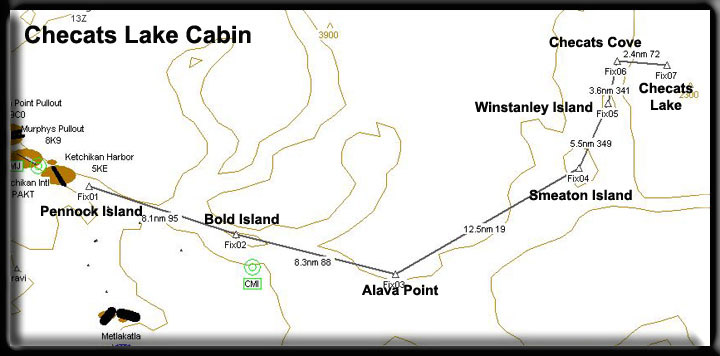
Ella
Narrows Cabin (See
Note 3)
Minimum ceiling: 2000 feet 
Minimum flying altitude: 1700 feet
Minimum visibility: 1 mile
Approximate distance: 24 miles
FSNavigator files [here]
Enlarged Map [here]
Printer Friendly plan [here]
Direct from Mountain Point to Cabin: 17 miles at 030
Direct from Cabin to Mountain Point: 17 miles at 210
VFR Directions: To the Cabins
- After leaving PAKT or 5KE, position over Pennock Island in
the Tongass Narrows at a heading of 110
- At the south end of Pennock Island, head toward Bold Island,
Set your heading at 094. Bold Island is 9 miles ahead. [5.4
minutes]
- At the south end (far end) of Bold Island, set a heading
for 068 for Cone Point, 3.7 miles ahead. [2 minutes]
- Fly over Cone Island over Cone Point and change heading to
360 heading for Evo Point, distance 5 miles [3 minutes]
- At Evo Point, set heading of 008 for Gokachin Lakes, approaching
these, your altitude must be 1700 feet minimum. [4 minutes]
- At Gokachin Lakes, slightly correct heading for 358. Ella
Lake is 3 miles ahead. Begin dropping altitude and head for
the center of the lake [2 minutes]
- Continue straight straight ahead to the end of the lake,
the cabin is there.
VFR Directions: Returning to Ketchikan
- After leaving either cabin, head for the center of the lake
and begin climbing to 1700 feet. Once at the center of the
lake, select a heading of 178, continue climb to 1700.
- Fly 3 miles to Gokachin Lakes and reset heading for 183 direct
to Cone Point (11.5 miles). [7 minutes]
- At Cone Point, set a heading of 252 for Bold Island, 3.7
miles [1.5 minutes]
- Over Bold Island, set a heading of 274 for Pennock Island
[5.5 minutes]... you are now in the Tongass Narrows and ATC
should be directing your destination.
Description: This is a rustic style 12' x 14' Pan-Abode
log cabin with a wood-burning stove and sleeping space for 4
to 6 people. The cabin was constructed in 1966.
Location: Approximately 24 air miles northeast of Ketchikan
on Revillagigedo Island on the north end of Ella Lake.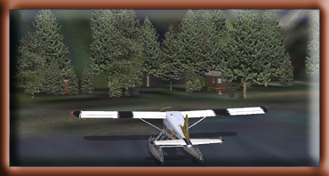 It
is accessible by float plane or canoe. This cabin is located
within the Misty Fiords National Monument Wilderness. Please
Leave No Trace of your visit. It
is accessible by float plane or canoe. This cabin is located
within the Misty Fiords National Monument Wilderness. Please
Leave No Trace of your visit.
Season of Use: Year-around.
Facilities: 2 single plywood bunks, 2 double plywood
bunks, Table and benches, Wood stove, Cooking counter, Food cupboard
and shelves, Broom, mop and bucket, Outhouse toilet, Axe Maul
and wedge, 14' aluminum skiff with oars and NO life jackets.
Water is available from the lake or a creek near the
cabin. Treat all water before using. Bring your own sleeping
bags, sleeping pads, cooking stove, lantern, pots, pans, plates,
utensils, food, toilet paper, garbage bags, fire extinguisher
and fire starter. This cabin contains a wood stove. Please conserve
firewood; supplied firewood is for wood stove use only.
Special Features: The cabin features a long stretch of
cobble beach with a large white sand beach close to the cabin.
This location is great for families, providing a lot of space
for the kids to run around. The cabin is located away from the
beach in a stand of large old-growth spruce, hemlock, and cedar.
This lake has one other cabin, Red Alders Cabin, located on the
northwest arm of the lake. Fishing is rated as excellent for
cutthroat, dolly varden, and kokanee (land locked salmon). Hunting
for Sitka blacktail deer and black bear is popular in this area.
Beaver, mink, marten, and many bird species are common.
Back to Index or Back
to Top
|
|
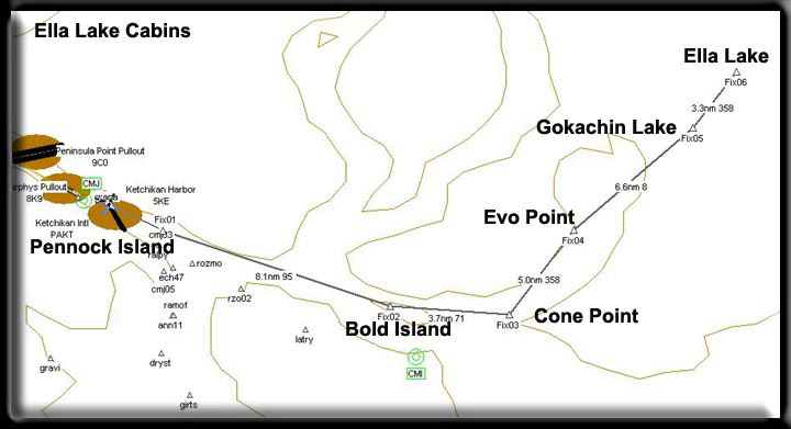
Hugh
Smith Lake Cabin (see
note 13)
Minimum ceiling: 2000 feet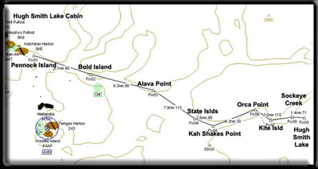
Minimum flying altitude: 1500 feet
Minimum visibility: 1 mile
Approximate distance: 55 miles
FSNavigator files [here]
Enlarged Map [here]
Printer Friendly plan [here]
Direct from Mountain Point to Cabin: 32 miles at 086
Direct from Cabin to Mountain Point: 32 miles at 267
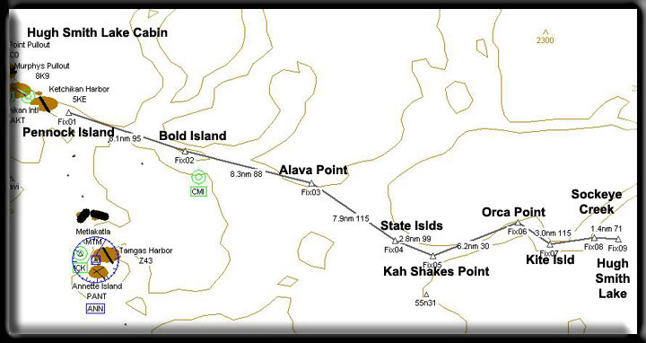
VFR Directions: To the Island Cabin
- After leaving PAKT or 5KE, position over Pennock Island in
the Tongass Narrows at a heading of 110
- At the south end of Pennock Island, head toward Bold Island,
Set your heading at 094. Bold Island is 9 miles ahead. [5.5
minutes]
- At the south end of Bold Island, set a heading for 088 for
Alava Point, the point of land 8.3 miles ahead. [5 minutes]
- At Alava Point set your heading at 115 for the State Islands
8 miles ahead [4.5 minutes]
- Over the State Islands, set a heading of 097 for Kah Shakes
Point 3 miles ahead. [1.5 minutes]
- At Kah Shakes point, set a heading of 029 heading for Orca
Point 6.2 miles ahead. You are flying up the Boca de Quadra
channel [3.5 minutes]
- Orca Point comes on on your right, and this is where you
will make a right turn to 114 degrees for the tiny Kite Island
in the center of the channel, 3 miles ahead. [1.5 minutes]
- Over Kite Island, set a heading of 050 heading for Sockeye
Creek that you can see emptying from Hugh Smith Lake, just
beyond. Reduce altitude to 1200 feet to prepare for landing
about 5 miles ahead. [2 minutes]
- As you come over the shore of Hugh Smith Lake a correction
to your right by 5 degrees and fly down the lake. The Hugh
Smith Cabin is toward the end of the lake on the right.
VFR Directions: Returning to Ketchikan
- Taxi out in front of the cabin and set your heading for about
240 to fly down the lake and take off. Fly the lake to go over
Sockeye Creek.
- As you come over Sockeye Creek, you should set a heading
for Kite Island, 3 miles ahead at a heading of 230. [1.5 minutes]
- At Kite Island, turn to 295 heading for Orca Point about
3 miles ahead on the left. At Orca Point you will turn left.[2
minutes]
- Round Orca Point and come to a heading of 210 which will
take you to Kah Shakes Point about 6 miles ahead [3.5 minutes]
- At Shakes Point, you can set a heading of 279 for the small
State Islands.
- At the State Islands, set a heading of 295 to Alava Point
about 8 miles ahead [4.5 minutes]
- At Alava Point, set a heading of 269 for Bold Island 8.3
miles ahead. [5 minutes]
- Over Bold Island, set a heading of 275 for Pennock Island
[5.5 minutes] ... you are now in the Tongass Narrows and ATC
should be directing your destination.
Description: This is a rustic style 12' x 14' Pan-Abode
log cabin with a wood-burning stove and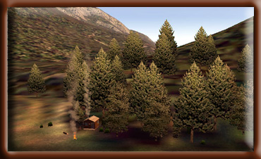 sleeping
space for 4 to 6 people. The cabin was constructed in 1965. sleeping
space for 4 to 6 people. The cabin was constructed in 1965.
Location: Approximately 55 air miles southeast of Ketchikan
on the mainland south of Martin Arm, elevation 100 feet (30 meters).
It is accessible by float plane. In fall, winter and early spring,
the cabin may be inaccessible due to the frozen lake surface
(float planes cannot land). This cabin is located within the
Misty Fiords National Monument Wilderness. Please Leave No Trace
of your visit.
Season of Use: Year-around.
Facilities:2 single plywood bunks, 2 double plywood bunks,
Table and benches, Wood stove, Cooking counter, Food cupboard
and shelves, Broom, mop and bucket, Outhouse toilet, Axe, Maul
and wedge, 14' aluminum skiff with oars and NO life jackets
Water is available from the lake. Treat all water before
using. Bring your own sleeping bags, sleeping pads, cooking stove,
lantern, pots, pans, plates, utensils, food, toilet paper, garbage
bags, fire extinguisher and fire starter. This cabin contains
a wood stove. Please conserve firewood; supplied firewood is
for wood stove use only.
Special Features: The cabin is located on a point of
land extending into Hugh Smith Lake. Along with the standard
opportunities provided at our cabins, this cabin offers something
a little different. For those of you who enjoy exploring some
of Southeast Alaskan History, there is an old abandoned cannery
on the east end of the lake. A trail to salt water, a working
fish weir, and a cabin used by Alaska Department of Fish and
Game are located at the west end of the lake. This lake has good
cutthroat and dolly varden fishing as well as salmon fishing.
Hunting for Sitka blacktail deer and black bear is popular in
this area.
Back to Index or Back
to Top
|
|
Humpback
Lake Cabin (see
note 14)
Minimum ceiling: 2000 feet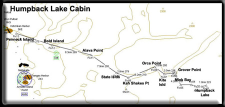
Minimum flying altitude: 1500 feet
Minimum visibility: 1 mile
Approximate distance: 55 miles
FSNavigator files [here]
Enlarged Map [here]
Printer Friendly plan [here]
Direct from Mountain Point to Cabin: 37 miles at 090
Direct from Cabin to Mountain Point: 37 miles at 270
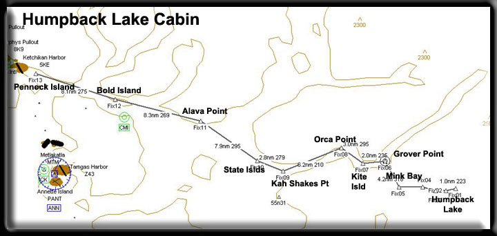
VFR Directions: To the Island Cabin
- After leaving PAKT or 5KE, position over Pennock Island in
the Tongass Narrows at a heading of 110
- At the south end of Pennock Island, head toward Bold Island,
Set your heading at 094. Bold Island is 9 miles ahead. [5.5
minutes]
- At the south end of Bold Island, set a heading for 088 for
Alava Point, the point of land 8.3 miles ahead. [5 minutes]
- At Alava Point set your heading at 115 for the State Islands
8 miles ahead [4.5 minutes]
- Over the State Islands, set a heading of 097 for Kah Shakes
Point 3 miles ahead. [1.5 minutes]
- At Kah Shakes point, set a heading of 029 heading for Orca
Point 6.2 miles ahead. You are flying up the Boca de Quadra
channel [3.5 minutes]
- Orca Point comes on on your right, and this is where you
will make a right turn to 114 degrees for the tiny Kite Island
in the center of the channel, 3 miles ahead. [1.5 minutes]
- Over Kite Island, set a heading of 050 to round Grover Point,
the point about 2 miles ahead on your right. You will see Hugh
Smith Lake and Sockeye Creek coming up but you will turn to
starboard before reaching them into Mink Bay.
- Go to the right around Grover Point to a heading of 134 ...
this is Mink Bay.
- Toward the end of Mink Bay, you will see Humpback Creek emptying
into the bay. Turn left at Humpback Creek to a heading of 064
for about a mile until you reach the edge of Humpback Lake.
Turn to starboard (right) into the lake and follow it around
the "hump". You should begin to reduce altitude as
you will land in 3 miles.
- The cabin will come up on the left just before the part of
the lakes where the sides constrict ... about 3 miles.
VFR Directions: Returning to Ketchikan
- Taxi out in front of the cabin and set your heading for about
220 taking off and flying down the lake. Go around the humpback
(veering left then around to the right) watching for the end
of the lake.
- When the end of the lake appears, you will see the Humpback
Creek area ... set a heading of 245 to fly back to Mink Bay.
- Over Mink Bay, set a heading of 318 to fly up the bay to
Grover Point. You will be going to port (left) around Grover
Point.
- At Grover point, set a heading for Kite Island, 3 miles ahead
at a heading of 230. [1.5 minutes].
- At Kite Island, turn to 295 heading for Orca Point about
3 miles ahead on the left. At Orca Point you will turn left.
[1.5 minutes]
- Round Orca Point and come to a heading of 210 which will
take you to Kah Shakes Point about 6 miles ahead [3.6 minutes]
- At Shakes Point, you can set a heading of 279 for the small
State Islands.
- At the State Islands, set a heading of 295 to Alava Point
about 8 miles ahead [4.8 minutes]
- At Alava Point, set a heading of 269 for Bold Island 8.3
miles ahead. [5 minutes]
- Over Bold Island, set a heading of 275 for Pennock Island
[5.5 minutes] ... you are now in the Tongass Narrows and ATC
should be directing your destination.
Description: This is a rustic style 12' x 14' Pan-Abode
log cabin with an oil stove for heat and sleeping 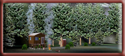 space
for 4 to 6 people. The cabin was built in 1979. space
for 4 to 6 people. The cabin was built in 1979.
Location: Approximately 48 air miles (77 km) southeast
of Ketchikan on the mainland east of Mink Bay. It is accessible
by float plane. In fall, winter and early spring, the cabin may
be inaccessible due to the frozen lake surface (float planes
cannot land). This cabin is located within the Misty Fiords National
Monument Wilderness. Please Leave No Trace of your visit.
Season of Use: Year-around.
Facilities: 2 single plywood bunks, 2 double plywood
bunks, Table and benches, Oil stove (uses #1 fuel oil, NOT provided),
Cooking counter, Food cupboard and shelves, Broom, mop and bucket,
Outhouse toilet, 14' aluminum skiff with oars and NO life jackets
Water is available from the lake. Treat all water before
using. Bring your own #1 fuel oil for the stove, personal flotation
devices, sleeping bags, sleeping pads, cooking stove, lantern,
pots, pans, plates, utensils, food, toilet paper, garbage bags,
fire extinguisher and fire starter.
Special Features: The cabin features spectacular views
of high alpine peaks with sheer granite walls. This location
has the feel of complete solitude, but you are not alone. There
are a few abandoned structures around the lake and a single structure
commercial lodge located at the southeast end. If you are into
a lengthy paddle and a beautiful hike, the Humpback Creek Trail
(#715) is located at the west end of the lake. This trail was
reconstructed in 1995 and offers a great view of Humpback Falls.
Please note that the trailhead is located behind a large log
jam at the very end of the lake. Fishing is rated as excellent
for dolly varden and cutthroat trout. Hunting for Sitka blacktail
deer, black and brown bear, and mountain goat is popular in this
area.
Back to Index or Back
to Top
|
|
Kegan
Cove Cabin (see
note 16)
Minimum ceiling: 1000 feet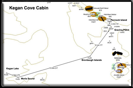
Minimum flying altitude: 1000 feet
Minimum visibility: 1 mile
Approximate distance: 55 miles
FSNavigator files [here]
Enlarged Map [here]
Printer Friendly plan [here]
Direct from Gravina Point to Cabin: 24 miles at 204
Direct from Cabin to Gravina Point: 24 miles at 024
VFR Directions: To the Kegan Cove Cabin
- After leaving PAKT or 5KE, position over the center Pennock
Island in the Tongass Narrows at a heading of 110
- At the midpoint of Pennock Island, set a heading of 141 to
Gravina Point. This is the point of land at the southern most
tip of Gravina Island (the large island on your right), about
2.9 miles distant. Prepare for a course correction to starboard.
- At Gravina Point, set a heading of 177 for 11 miles to the
Bronaugh Islands. You will turn into Nichols Passage. The small
settlement of China Town is across the passage to port at the
base of Red Mountain. As you make this turn, Blank Inlet will
be on your starboard side.
- As you are flying down the southern coast of Gravina Island,
you will fly past Bostwick Inlet, and a small cove called Seal
Cove. You will see the Dall Head come up at about 2 o'clock.
The Bronaugh Islands are about 2 miles off the southern coast
and should be ahead of you.
- At the Bronaugh Islands, set a course of 217 for the center
of Moria Sound on the Prince of Wales island. You will fly
over a group of islands at the mouth of the sound, Whiterock
Island will be first, then you will fly over Menefee Islands.
Rip Point will be to port.
- As you near the entrance of the South Arm (angling off to
your left) you will make a turn to starboard to a heading of
278. Kegan Lake is ahead of you. The smaller lake before Kegan
Lake is actually Kegan Cove. The cabin is on the near (south)
shore of Kegan Cove. If you are a good pilot, it is possible
to land safely on the cove, otherwise fly on to Kegan Lake
and taxi back to the cabin.
VFR Directions: Returning to Ketchikan
- Taxi to the north end of Kegan Lake to give yourself sufficient
room for a safe takeoff. You should set a heading of about
130. Just after you take off, fly over the cabin making a nice
turn to the left out over the water of Moria Sound. Once in
Moria Sound, set a heading for the mouth of the sound toward
Whiterock Island (heading of 040). You will fly over the Menefee
Islands to Whiterock Island just beyond.
- At Whiterock Island, set a course of 040 (you already may
be on this heading depending on how you flew to Whiterock Island).
Maintain this heading for 15.9 miles to the Bronaugh Islands.
The Dall Head is the mountain on the south side of Gravina
Island, this is a good visual waypoint to seek. However, as
you get closer, you will see the Bronaugh Islands, about 10
degrees to starboard. Head for those islands.
- Over the Bronaugh Islands, set a course for Gravina Point
at a heading of 357 for 10.5 miles. As you make this turn to
port, the Dall Head is to your left. A small cove coming up
on the left is Seal Cove with a larger inlet just beyond it
which is Bostwick Inlet. The next, and deeper inlet is Blank
Inlet. As You near Gravina Point, you should be contacting
Ketchikan ATC for approach instructions.
- Over Gravina point, you can set a heading of 332 that will
take you over the center of Pennock Island.
Description: This 12' x 14' Pan-Abode precut
cedarlog cabin was built in 1979. It has sleeping space for 4
to 6 people and a wood-burning stove for heat. precut
cedarlog cabin was built in 1979. It has sleeping space for 4
to 6 people and a wood-burning stove for heat.
Location: The cabin is located on saltwater at Moira
Sound, 51 miles (82 km) from Craig and 30 miles (48 km) from
Ketchikan.
Access: The cabin can be reached by float plane or boat.
It is accessible and available for use all year long. However,
April through November are often the best months. A mooring buoy
is located in the cove. A reservation for a Forest Service cabin
does not include exclusive use of the buoy. Buoy use is on a
first-come, first-served basis. Mooring of more than one vessel
is allowed, provided the first party there agrees. Occasionally
poor weather can result in extended stays, and cabin users should
be prepared for this.
Terrain: Terrain is generally flat with coastal Sitka
spruce-western hemlock forest predominating.
Facilities: 2 single plywood bunks, 2 double plywood
bunks, Table and benches, Wood stove and firewood, Cooking bench,
Broom, Outhouse toilet, Axe, Splitting maul, Mooring buoy
Water is available from Kegan Creek. Treat all water
before using. Bring your own sleeping bags, sleeping pads, cooking
stove, lantern, pots, pans, plates, utensils, food, toilet paper,
garbage bags, fire extinguisher and fire starter.
Special Features: The prolific salmon runs draw both
anglers and black bear to the popular creek. An excellent trail
meanders along Kegan Creek, connecting Kegan Cove and the cabin
on Kegan Creek 1/2 mile upstream. The trail is a good place to
watch fish or try to catch steelhead and trout. Eagles, sea gulls,
and a variety of other birds as well as Sitka black-tailed deer
also frequent the area.
Back to Index or Back
to Top
|
|
Manzanita
Lake Cabin (See
Note 15)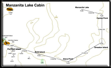
Minimum ceiling:2000 feet
Minimum flying altitude: 1700 feet
Minimum visibility: 1 mile
Approximate distance: 33 miles
FSNavigator files [here]
Enlarged Map [here]
Printer Friendly plan [here]
Direct from Mountain Point to Cabin: 23 miles at 013
Direct from Cabin to Mountain Point: 23 miles at 193
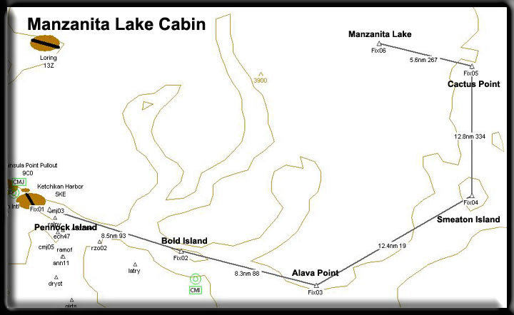
VFR Directions: To the cabin
- After leaving PAKT or 5KE, position over Pennock Island in
the Tongass Narrows at a heading of 110
- At the south end of Pennock Island, head toward Bold Island,
Set your heading at 094. Bold Island is 9 miles ahead. [5.5
minutes]
- At the south end of Bold Island, set a heading for 088 for
Alava Point, the point of land 8.3 miles ahead. [5 minutes]
- At Alava Point set your heading at 017 for Smeaton Island,
9.6 miles ahead. You will fly over Rudyerd Island during this
leg. At this point, you are in the Behm Canal, a body of water
that circles the Ketchikan Area. [6 minutes]
- At Smeaton Island, set your heading at 334 for Cactus Point.
This point juts out from the port side of the channel helping
to form Sargents Bay. [7.5 minutes]
- At the leading edge of Cactus Point turn left to a heading
of 267. You will see Manzanita Lake 5.6 miles ahead. [3 minutes]
This lake has two branches, you are lined up on the branch
where the cabin is located. Fly down this branch and land toward
the end of the lake. The cabin is on your left at the end of
the lake.
VFR Directions: Returning to Ketchikan
- Leave the lake on a heading of 087 heading for Cactus Point,
about 5 miles ahead. [3 minutes]
- Over Cactus Point, turn to a heading of 154 for 13 miles.
This takes you to Smeaton Island. [7.8 minutes]
- At Smeaton Island, set a course for Alava Point at a heading
of 199, 12.4 miles ahead. [7.5 minutes]
- At Alava Point, set a heading of 269 for Bold Island 8.3
miles ahead. [5 minutes]
- Over Bold Island, set a heading of 275 for Pennock Island
[5.5 minutes] ... you are now in the Tongass Narrows and ATC
should be directing your destination.
Description: This is a rustic style 12' x 14' Pan-Abode
log cabin with a oil-burning stove (use #1 diesel fuel) and sleeping
space for 4 to 6 people. The cabin was constructed in 1973.
Location: About 28 air miles northeast of Ketchikan, on Revillagigedo
Island on the scenic northwest arm of Manzanita Lake. Accessible
by float plane. In fall, winter and early spring, the cabin may
be inaccessible due to the frozen lake surface (float planes
cannot land). This cabin is located within the Misty Fiords National
Monument Wilderness. Please Leave No Trace of your visit.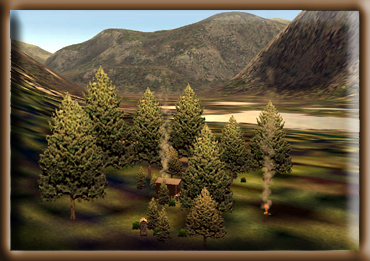
Season of Use: Year-around.
Facilities: 2 single plywood bunks, 2 double plywood
bunks, Table and benches, Oil stove (fuel not provided), Cooking
counter, Food cupboard and shelves, Broom, mop and bucket, Outhouse
toilet, 14' aluminum skiff with oars and NO life jackets
Water is available from a nearby creek or the lake.
Treat all water before using. Bring your own fuel oil (#1 diesel
only) for the oil stove, personal flotation devices, sleeping
bags, sleeping pads, cooking stove, lantern, pots, pans, plates,
utensils, food, toilet paper, garbage bags, fire extinguisher
and fire starter.
Special Features: This cabin is ideal for those who love
to fall asleep to the sound of falling water. The cabin is located
about 100 yards from the lake shore beside a spectacular series
of cascading waterfalls. If the falls don't tempt you, then the
view of steep granite walls and snow-capped peaks will. This
glaciated valley is one of a kind and you are in the middle of
it. The cabin is also surrounded by large old-growth spruce,
hemlock, and cedar. The lake has one other cabin, Beaver Cabin,
located on the south arm of the lake. Fishing is rated as excellent
for cutthroat, dolly varden, and kokanee (land-locked salmon).
Hunting for Sitka blacktail deer and black bear is popular in
this area. Beaver, mink, and marten are common.
Back to Index or Back
to Top
|
|
McDonald Lake
Cabin (See
Note 18)
Minimum ceiling:2000 feet 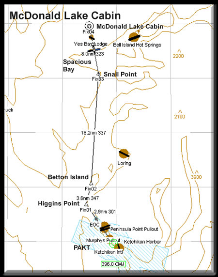
Minimum flying altitude: 1500 feet
Minimum visibility: 1 mile
Approximate distance: 50 miles
FSNavigator files [here]
Enlarged Map [here]
Printer Friendly plan [here]
Direct from Mountain Point to Cabin: 23 miles at 013
Direct from Cabin to Mountain Point: 23 miles at 193
VFR Directions: To the cabin
- After leaving PAKT, position going northwest up the Tongass
Narrows, heading 301 for 2.9 miles to Higgins Point, the point
of land on the right at the mouth of the Tongass Narrows.
- At Higgins Point, look about 1 o'clock and you'll see a large
island. This is Betton Island. Set a heading of 347 to cross
over the center of Betton Island. The distance is about 3.6 miles.
As you approach Betton Island, Clover Passage will be on your
right. You are flying up the Behm Canal (this circles Revillagigedo
Island, the island Ketchikan is on).
- At Betton Island, set a heading of 337 for 18.2 miles heading
for Snail Point. Pick a point on the horizon and fly to it as
the wind can change your intended heading greatly on this leg.
The island off to your right is Grant Island with Loring Bay
behind it. The point coming up ahead on the right 8 miles away
is Indian Point. To your left you will see Helm Bay and Helm
Point. 15 miles ahead is what looks like a bay, this is Yes Bay.
The point to the left of that bay is Snail Point.
- At Snail point, set a heading of 323 for 8 miles to the cabin
on McDonald lake. The lake is tucked behind a low ridge and you
will see it as you draw nearer to the coast. As you cross the
coast, you still have about 5 miles till you reach the lake.
You will cross over the south part of the lake, then over some
land. Look to the base of the mountain ahead. The cabin is located
on a tiny island on the right side of the lake near the base
of the mountain.
VFR Directions: Returning to Ketchikan
- Leave the lake on a heading of 143 heading for Snail Point.
You will fly over Spacious Bay with Yes Bay to port.
- At Snail Point, set a heading of 157, heading for Betton Island,
18.7 miles distant.
- Over Betton Island, set a heading for Higgins Point, heading
of 168 for 3 miles.
- At Higgins point, turn into the Tongass Narrows and head toward
PAKT. (Heading 121)
Description: This is a rustic style 12' x 14'
Pan-Abode log cabin with a wood-burning stove and sleeping space
for 4 to 6 people. The cabin was constructed in 1967.
Location: About 50 miles from Ketchikan. McDonald
Lake is located on Cleveland Peninsula north of Yes Bay. The cabin
site is on Wolverine Island near the outlet of McDonald Lake. It
is accessible by floatplane or boat. In fall, winter and early
spring, the cabin may be inaccessible due to the frozen lake surface
(float planes cannot land). A hike from Yes Bay to McDonald Lake
via a 1.5 mile trail provides salt water access. There is no buoy
at the trailhead.
Season of Use: April through October.
Facilities: 2 single plywood bunks, 2 double
plywood bunks, Table and benches, Wood stove Cooking counter, Food
cupboard and shelves, Broom, mop and bucket, Outhouse toilet, Wood
shed, Skiff with oars and NO life jackets
Water is available from a nearby creek. Treat all
water before using. Bring your own personal flotation devices, sleeping
bags, sleeping pads, cooking stove, lantern, pots, pans, plates,
utensils, food, toilet paper, garbage bags, fire extinguisher and
fire starter. This cabin contains a wood stove. Please conserve firewood;
supplied firewood is for wood stove use only.
Additional Comments: The skiff at this cabin
uses a short shaft motor (not provided). Oars are provided; life
jackets are NOT provided.
Special Features: This cabin is located in an old-growth cedar,
Sitka spruce, and western hemlock rain forest. There is trail access
to Wolverine Creek and a 1930s Civilian Conservation Corp (CCC)
3-sided shelter. There are steelhead and salmon runs up to Wolverine
Creek with resident trout and dolly varden throughout the lake.
Wildlife in the area include Sitka blacktail deer, black bear,
beaver, wolf, marten, mink, and otter.
Back to Index or Back
to Top
|
|
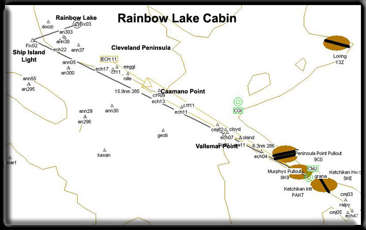
Rainbow Lake
Cabin (See
Note 17)
NOTE: This cabin has a difficult approach. You cannot trust
FSNavigator4 because of the final turn. So NO FSNavigator4 planning
files have been included for this cabin. This is pure VFR, and
a difficult approach. You must fly between some ridges and after
clearing the last one at 1200 feet, drop quickly to the surface
of the lake for a landing. As you make the final turn, you should
set up for landing configuration and slow speed. Be careful with
this one!
Minimum ceiling:2000 feet 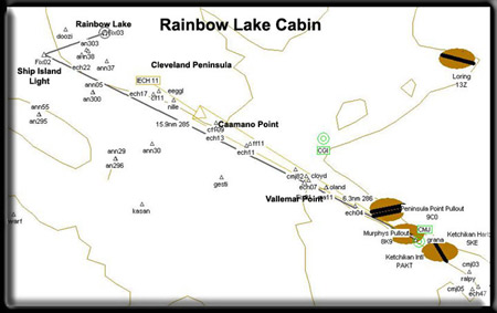
Minimum flying altitude: 1200 feet
Minimum visibility: 3 mile
Approximate distance: 15 miles
FSNavigator files NOT INCLUDED with this cabin.
Enlarged Map [here]
Printer Friendly plan [here]
Direct from Vallemar Point to Cabin: 15 miles at 296
Direct from Cabin to Vallemar Point: 117 miles at 193
VFR Directions: To the cabin
- Center over the Tongass Narrows at a heading of about 292.
Head for Vallemar Point, the final land point on Gravina Island
to port.
- From Vallemar Point, set a heading for 285 which will take
you near the coast of the Cleveland Peninsula. You should visually
head for Caamano Point, the most southern tip of the peninsula,
about 8 miles. Follow the western coastline of the peninsula
for about 10 miles watching VERY closely for a tiny island
named Ship Island Light.
- At Ship Island Light, you will be making a hard turn to starboard
coming to a heading of 032, flying around the small mountain
to your right. Rainbow Lake is 3.3 miles ahead and not visible
until you are almost upon it. You must maintain at least 1200
feet to clear the last ridge before you drop quickly to the
lake. Be in landing configuration just after your turn at Ship
Island Light.
- The Cabin is located on the far side of the lake (eastern
shore).
VFR Directions: Returning to Ketchikan
- Start out almost in front of the Rainbow Lake Cabin, and
set a heading of 211.
- Take off at full throttle to clear the ridge ahead of you.
- Once you get to the channel, you will see the Ship Island
Light.
- At the Ship Island light, set a heading of about 105 degrees
and follow the western coast south toward Caamano Point.
- At Caamano Point, set a heading of 110 degrees to fly to
Vallemar Point, the northern point of Gravina Island. You should
be talking to Ketchikan ATC by this point for approach instructions.
Description: This is a rustic style 12' x 14' 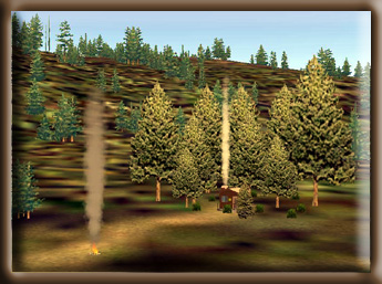 Pan-Abode
log cabin with an oil-burning stove for heat, and sleeping space
for 4 to 6 people. The cabin was built in 1968. Pan-Abode
log cabin with an oil-burning stove for heat, and sleeping space
for 4 to 6 people. The cabin was built in 1968.
Location: About 27 miles (43.5 km) from Ketchikan. The
cabin is located on the southern end of Cleveland Peninsula between
Clarence Strait and Helm Bay. It is on the north shore of Rainbow
Lake at an elevation of 650 feet (200 meters). It is accessible
by float plane. In fall, winter and early spring, the cabin may
be inaccessible due to the frozen lake surface (float planes
cannot land).
Season of Use: May through October.
Facilities: 2 single plywood bunks, 2 double plywood
bunks, Table and benches, Oil stove (uses #1 diesel, NOT provided),
Cooking counter, Food cupboard and shelves, Broom, mop and bucket,
Outhouse toilet
Water is available from a nearby creek. Treat all water
before using. Bring your own stove oil (#1 stove oil or kerosene
only), sleeping bags, sleeping pads, cooking stove, lantern,
pots, pans, plates, utensils, food, toilet paper, garbage bags,
fire extinguisher and fire starter.
Additional Comments: Currently there is no skiff provided
at this cabin.
Special Features: This cabin is located in the upper
reaches of old-growth cedar, Sitka spruce, and western hemlock
rain forest with lodgepole pine in the vicinity of the cabin.
There are open views of muskegs and peaks across the lake from
the cabin. The lake has a resident population of rainbow trout.
Wildlife in the area include Sitka blacktail deer, black bear,
mountain goat, and wolf.
Back to Index or Back
to Top
|
|
Red Alders Cabin (See
Note 2)
Minimum ceiling: 2000 feet
Minimum flying altitude: 1700 feet
Minimum visibility: 1 mile
Approximate distance: 24 miles
FSNavigator files [here]
Enlarged Map [here]
Printer Friendly plan [here]
Direct from Mountain Point to Cabin: 17 miles at 030
Direct from Cabin to Mountain Point: 17 miles at 210
Note: For FSNavigator, the plans used for this flight are "TO
and FROM ellalake.fsn" the cabin is on the same lake as
the Ella Narrows Cabin.
VFR Directions: To the Cabins
- After leaving PAKT or 5KE, position over Pennock Island in
the Tongass Narrows at a heading of 110
- At the south end of Pennock Island, head toward Bold Island,
Set your heading at 094. Bold Island is 9 miles ahead. [5.5
minutes]
- At the south end (far end) of Bold Island, set a heading
for 068 for Cone Point, 3.7 miles ahead. [2 minutes]
- Fly over Cone Island over Cone Point and change heading to
360 heading for Evo Point, distance 5 miles [3 minutes]
- At Evo Point, set heading of 008 for Gokachin Lakes 6.6 miles,
approaching these, your altitude must be 1700 feet minimum.
[4 minutes]
- At Gokachin Lakes, slightly correct heading for 358. Ella
Lake is 3 miles ahead. Begin dropping altitude and head for
the center of the lake [2 minutes]
- At the center of the lake, take the left branch (heading
310) and this cabin is at the end of this branch of the lake.
VFR Directions: Returning to Ketchikan
- After leaving either cabin, head for the center of the lake
and begin climbing to 1700 feet. Once at the center of the
lake, select a heading of 178, continue climb to 1700..
- Fly 3 miles to Gokachin Lakes and reset heading for 183 direct
to Cone Point (11.5 miles). [7 minutes]
- At Cone Point, set a heading of 252 for Bold Island, 3.7
miles [2 minutes]
- Over Bold Island, set a heading of 274 for Pennock Island
[5.5 minutes]... you are now in the Tongass Narrows and ATC
should be directing your destination.
Description: This is a rustic style 12' x 12' Pan-Abode
log cabin with a wood-burning stove and sleeping space for 4
to 6 people. The cabin was constructed in 1962.
Location: Approximately 24 air miles northeast of Ketchikan
on Revillagigedo Island on the north end of Ella Lake. It is
accessible by float plane or canoe. In fall, winter and early
spring, the cabin may be inaccessible due to the frozen lake
surface (float planes cannot land). This cabin is located within
the Misty Fiords National Monument Wilderness. Please Leave No
Trace of your visit. 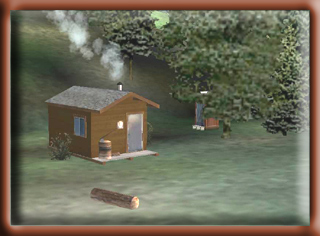
Note: Look at the smoke in the picture to
the right. Notice it will drift in different directions depending
upon the wind direction at the time! This is a nice feature
of the Misty Fjords scenery package ... the smoke can give
you and indication of wind direction so you can choose a
safe landing.
Season of Use: Year-around.
Facilities: 2 single plywood bunks, 2 double plywood
bunks, Table and benches, Wood stove, Cooking counter, Food cupboard
and shelves, Broom, mop and bucket, outhouse toilet, Axe, Maul
and wedge, 14' aluminum skiff with oars and NO life jackets (unless
you are flown in).
Water is available from the lake. Treat all water before
using. Bring your own sleeping bags, sleeping pads, cooking stove,
lantern, pots, pans, plates, utensils, food, toilet paper, garbage
bags, fire extinguisher and fire starter. This cabin contains
a wood stove. Please conserve firewood; supplied firewood is
for wood stove use only.
Special Features: The cabin is located on the lake shore
in an old-growth stand of spruce, hemlock, and cedar with a thick
understory of red alder. This cabin features a flat cobblestone
beach with a small section of sandy beach. There is an open muskeg
close to the cabin with many of the plant species found in Southeast
Alaska. It is also common to see deer grazing in this area. The
lake has one other cabin, Ella Narrows Cabin, located on the
north arm of the lake. Fishing is rated as excellent for cutthroat,
dolly varden, and kokanee (land locked salmon). Hunting for Sitka
blacktail deer and black bear is popular in this area. Beaver,
mink, marten, and many bird species are common.
Back to Index or Back
to Top
|
|
Wilson Narrows
Cabin (See
Note 7)
Minimum ceiling: 2000 feet 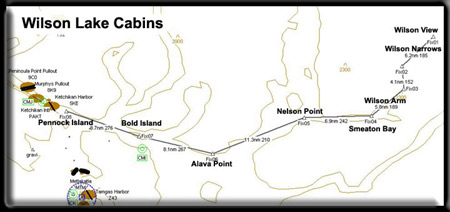
Minimum flying altitude: 1700 feet
Minimum visibility: 1 mile
Approximate distance: 44 miles
FSNavigator files [here]
Enlarged Map [here]
Printer Friendly plan [here]
Direct from Mountain Point to Cabin: 37 miles at 41
Direct from Cabin to Mountain Point: 37 miles at 221
VFR Directions: To the Island Cabin
- After leaving PAKT or 5KE, position over Pennock Island in
the Tongass Narrows at a heading of 110
- At the south end of Pennock Island, head toward Bold Island,
Set your heading at 094. Bold Island is 9 miles ahead. [5.5
minutes]
- At the far end of Bold Island, set a heading for 088 for
Alava Point, this is the point of land 8.3 miles ahead. [5
minutes]
- At Alava Point set a heading for Nelson Point 030 which is
11.3 miles ahead up the Behm Canal. [7 minutes]
- At Nelson Point, we set a heading of 064. You are entering
Smeaton Bay.
- At a distance of 7 miles [about 4 minutes] , you will see
the Wilson Arm of Smeaton Bay veering off to port (left). (The
Bakewell Arm is straight ahead). Set a heading of 010 for about
6 miles. [3.5 minutes]
- The Wilson Arm ends where the Wilson River flows into it.
At the Wilson River, set a heading of 330 degrees and follow
the river to Wilson Lake. [ 3 minutes]
- The Wilson Narrows Cabin is located near where the Wilson
River leaves Wilson lake. So as you approach the lake, prepare
to land. The cabin will be on your starboard side as you come
over the lake.
VFR Directions: Returning to Ketchikan
- Take off from Wilson Lake and fly a heading of 185 (toward
the south end of the lake) about 3 miles.
- At the south end of the lake, begin following the Wilson
River down to the Thorne Arm of Smeaton Bay, approximately
5 miles. (Approximate heading 150). {3 minutes]
- Turn right into the Wilson Arm and fly an approximate heading
of 187, making a correction about 3 miles later to 240 heading
toward the Behm Canal.
- Fly to Nelson Point, which is the point to the left of Smeaton
Bay (this channel) and here you enter the Behm Canal.
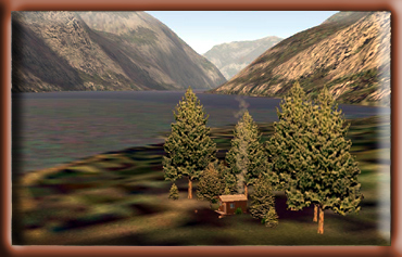
- At Nelson Point, set a heading of 210 for Alava Point 11.3
miles ahead. [7 minutes]
- At Alava Point, set a heading of 267 for Bold Island, 8.1
miles ahead. [5 minutes]
- Over Bold Island, set a heading of 275 for Pennock Island
(8.7 miles) [... you are now in the Tongass Narrows and ATC
should be directing your destination. [5.5 minutes]
Description: This is a rustic style 12' x 14' Pan-Abode
log cabin with a wood-burning stove and sleeping space for 4
to 6 people. The cabin was constructed in 1964.
Location: Approximately 44 air miles (71 km) east of Ketchikan
on the mainland north of Wilson Arm at the south end of Wilson
Lake, elevation 256 feet (78 m). It is accessible by float plane.
In fall, winter and early spring, the cabin may be inaccessible
due to the frozen lake surface (float planes cannot land). This
cabin is located within the Misty Fiords National Monument Wilderness.
Please Leave No Trace of your visit.
Season of Use: Year-around.
Facilities: 2 single plywood bunks, 2 double plywood
bunks, Table and benches. Wood stove. Cooking counter. Food cupboard
and shelves. Broom, mop and bucket. Outhouse toilet, Axe, Maul
and wedge, 14' aluminum skiff with oars and NO life jackets
Water is available from the lake. Treat all water before
using. Bring your own sleeping bags, sleeping pads, cooking stove,
lantern, pots, pans, plates, utensils, food, toilet paper, garbage
bags, fire extinguisher and fire starter. This cabin contains
a wood stove. Please conserve firewood; supplied firewood is
for wood stove use only.
Special Features: A fishing paradise. The cabin lies
on the south end of this long and narrow glacially carved lake.
While you fish you can enjoy the rugged terrain looming overhead.
Just imagine - Big Goat Lake is 2,000 feet (610 m) above you
to the north. The outlet of the lake is abundant with excellent
cutthroat, dolly varden, and kokanee (land locked salmon) fishing.
Remember to purchase your fishing license before leaving for
the cabin. Besides fishing, hunting for mountain goat, Sitka
blacktail deer, black bear, and brown bear all occurs in this
area.
Back to Index or Back
to Top
|
|
Wilson View Cabin (See
Note 8)
Minimum ceiling: 2000 feet Minimum flying altitude: 1700 feet
Minimum visibility: 1 mile
Approximate distance: 45 miles
FSNavigator files [here]
Enlarged Map [here]
Printer Friendly plan [here]
Direct from Mountain Point to Cabin: 37 miles at 41
Direct from Cabin to Mountain Point: 37 miles at 221
VFR Directions: To the Island Cabin
- After leaving PAKT or 5KE, position over Pennock Island in
the Tongass Narrows at a heading of 110
- At the south end of Pennock Island, head toward Bold Island,
Set your heading at 094. Bold Island is 9 miles ahead. [5.5
minutes]
- At the far end of Bold Island, set a heading for 088 for
Alava Point, this is the point of land 8.3 miles ahead. [5
minutes]
- At Alava Point set a heading for Nelson Point 030 which is
11.3 miles ahead up the Behm Canal. [7 minutes]
- At Nelson Point, we set a heading of 064. You are entering
Smeaton Bay.
- At a distance of 7 miles [about 4 minutes] , you will see
the Wilson Arm of Smeaton Bay veering off to port (left). (The
Bakewell Arm is straight ahead). Set a heading of 010 for about
6 miles. [3.5 minutes]
- The Wilson Arm ends where the Wilson River flows into it.
At the Wilson River, set a heading of 330 degrees and follow
the river to Wilson Lake. [ 3 minutes]
- The Wilson View Cabin is located at the far end (north end)
of Wilson Lake. Fly up the lake near the end and you will find
the cabin on your right.
VFR Directions: Returning to Ketchikan
- Take off from Wilson Lake and fly a heading of 185 (toward
the south end of the lake) about 3 miles.
- At the south end of the lake, begin following the Wilson
River down to the Thorne Arm of Smeaton Bay, approximately
5 miles. (Approximate heading 150). [3 minutes]
- Turn right into the Wilson Arm and fly an approximate heading
of 187, making a correction about 3 miles later to 240 heading
toward the Behm Canal.
- Fly to Nelson Point, which is the point to the left of Smeaton
Bay (this channel) and here you enter the Behm Canal.
- At Nelson Point, set a heading of 210 for Alava Point 11.3
miles ahead. [7 minutes]
- At Alava Point, set a heading of 267 for Bold Island, 8.1
miles ahead. [5 minutes]
- Over Bold Island, set a heading of 275 for Pennock Island
(8.7 miles) ... you are now in the Tongass Narrows and ATC
should be directing your destination. [5.5 minutes]
Description: This is a rustic style 12' x 14' Pan-Abode
log cabin with an oil stove for heat and sleeping space for 4
to 6 people. The cabin was built in 1977.
Location: Approximately 44 air miles (71 km) east of
Ketchikan on the mainland north of Wilson Arm at the north 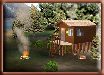 end
of Wilson Lake, elevation 256 feet (78 m). It is accessible by
float plane. In fall, winter and early spring, the cabin may
be inaccessible due to the frozen lake surface (float planes
cannot land). This cabin is located within the Misty Fiords National
Monument Wilderness. Please Leave No Trace of your visit. end
of Wilson Lake, elevation 256 feet (78 m). It is accessible by
float plane. In fall, winter and early spring, the cabin may
be inaccessible due to the frozen lake surface (float planes
cannot land). This cabin is located within the Misty Fiords National
Monument Wilderness. Please Leave No Trace of your visit.
Season of Use: Year-around.
Facilities: 2 single plywood bunks, 2 double plywood
bunks, Table and benches, Oil stove (uses #1 fuel oil, NOT provided),
Cooking counter, Food cupboard and shelves, Broom, mop and bucket,
Outhouse toilet, 14' aluminum skiff with oars and NO life jackets
Water is available from the lake. Treat all water before
using. Bring your own #1 fuel oil, personal flotation devices,
sleeping bags, sleeping pads, cooking stove, lantern, pots, pans,
plates, utensils, food, toilet paper, garbage bags, fire extinguisher
and fire starter. This cabin contains a wood stove. Please conserve
firewood; supplied firewood is for wood stove use only.
Special Features: The cabin lies on the north end of
this long and narrow glacially carved lake. While you explore
the inlet, you can enjoy the rugged terrain looming overhead.
Fishing and wildlife viewing around the inlet are great, so bring
your camera and fishing pole and spend some relaxing time on
the lake. If you're more of a hunter, hunting for mountain goat,
Sitka blacktail deer, black bear, and brown bear all occurs in
this area.
Back to Index or Back
to Top
|
Winstanley
Island Cabin (See
Note 6)
Minimum ceiling: 2000 feet
Minimum flying altitude: 1700 feet
Minimum visibility: 1 mile
Approximate distance: 45 miles
FSNavigator files [here]
Enlarged Map [here]
Printer Friendly plan [here]
Direct from Mountain Point to Cabin: 25 miles at 045
Direct from Cabin to Mountain Point: 25 miles at 226
VFR Directions: To the Island Cabin
- After leaving PAKT or 5KE, position over Pennock Island in
the Tongass Narrows at a heading of 110
- At the south end of Pennock Island, head toward Bold Island,
Set your heading at 094. Bold Island is 9 miles ahead. [3.6
minutes]
- At the south end of Bold Island, set a heading for 088 for
Alava Point, the point of land 8.3 miles ahead. [5 minutes]
- At Alava Point set your heading at 017 for Smeaton Island,
9.6 miles ahead. You will fly over Rudyerd Island on this leg.
At this point, you are in the Behm Canal, a body of water that
circles the Ketchikan Area. [6 minutes]
- At Smeaton Island, set your heading at 002 for Candle Island.
This is the small island at the southern tip of Winstanley
Island [4 minutes]
- Continue north over Winstanley Island. Toward the northern
tip, there is a cove on the eastern side. The Cabin is located
on that cove. [5 minutes]
VFR Directions: Returning to Ketchikan
- Select a heading for Candle Island (approximately 150 degrees)
- At Candle Island, set a heading of 182 that takes you over
Smeaton Island, 3.7 miles ahead. [2 minutes]
- At Smeaton Island, set a course for Alava Point at a heading
of 199, 12.4 miles ahead. [7.5 minutes]
- At Alava Point, set a heading of 269 for Bold Island 8.3
miles ahead. [5 minutes]
- Over Bold Island, set a heading of 275 for Pennock Island
[5.5 minutes] ... you are now in the Tongass Narrows and ATC
should be directing your destination.
Description: This is a rustic style 12' x 14' Pan-Abode
log cabin with a wood-burning stove and sleeping space for 4
to 6 people. The cabin was constructed in 1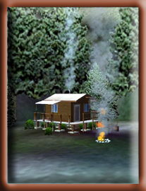 972. 972.
Location: Approximately 30 air miles (19 km) or 45 miles (72
km) by water east of Ketchikan on the east of the Behm Canal
between Rudyerd and Smeaton Bays. Located on salt water, it is
accessible by float plane or boat. A mooring buoy is provided.
This cabin is located within the Misty Fiords National Monument
Wilderness. Please Leave No Trace of your visit.
Season of Use: Year-around.
Facilities: 2 single plywood bunks, 2 double plywood
bunks, Table and benches, Wood stove. Cooking counter, Food cupboard
and shelves, Broom, mop and bucket, Outhouse toilet, Axe, Maul
and wedge. Mooring buoy.
Water is available from a creek near the cabin. Treat
all water before using. Bring your own sleeping bags, sleeping
pads, cooking stove, lantern, pots, pans, plates, utensils, food,
toilet paper, garbage bags, fire extinguisher and fire starter.
This cabin contains a wood stove. Please conserve firewood; supplied
firewood is for wood stove use only. Collect your own beach/driftwood
for campfires.
Additional Comments: There is no skiff provided at this
salt water site. A reservation for a Forest Service cabin does
not include exclusive use of the buoy. Buoy is on a first-come,
first-serve basis; however, mooring of more than one vessel is
allowed, provided the first party there agrees.
Special Features: There are a number of scenic attractions
within easy boating distance: Rudyerd Bay, Walker Cove, Chickamin
River, Smeaton Bay, and the entire east Behm Canal. Several trails
to fresh water streams and lakes and various hunting areas are
accessible by boat: Salt water fishing, wilderness exploration,
hiking, hunting, and beach combing are popular at this site.
Back to Index or Back
to Top
|
|
Winstanley Lake
Cabin (See
Note 5)
Minimum ceiling:2000 feet
Minimum flying altitude: 1700 feet
Minimum visibility: 1 mile
Approximate distance: 33 miles
FSNavigator files [here]
Enlarged Map [here]
Printer Friendly plan [here]
Direct from Mountain Point to Cabin: 25 miles at 045
Direct from Cabin to Mountain Point: 25 miles at 226
VFR Directions: To the Lake Cabin
- After leaving PAKT or 5KE, position over Pennock Island in
the Tongass Narrows at a heading of 110
- At the south end of Pennock Island, head toward Bold Island,
Set your heading at 094. Bold Island is 9 miles ahead. [5.5
minutes]
- At the south end of Bold Island, set a heading for 088 for
Alava Point, the point of land 8.3 miles ahead. [5 minutes]
- At Alava Point set your heading at 017 for Smeaton Island,
9.6 miles ahead. You will fly over Rudyerd Island during this
leg. At this point, you are in the Behm Canal, a body of water
that circles the Ketchikan Area. [5.5 minutes]
- At Smeaton Island, set your heading at 002 for Candle Island.
This is the small island at the southern tip of Winstanley
Island [3 minutes]
- At Candle Island, turn right to a heading of 028 ... this
is the heading for Winstanley Lake. There are two lakes on
this bearing, the one you want is the second one 3.1 miles
ahead. [2 minutes] Be careful on this approach at low altitudes,
there are 2600 foot features on both sides of your course.
- As you are over the lake, you may swing to starboard and
fly toward the cabin which is located on the east side of the
lake.
VFR Directions: Returning to Ketchikan
- Leave the lake on a heading of 199 heading for Candle Island,
about 2.7 miles ahead. [1 minutes]
- At Candle Island, set a heading of 182 that takes you over
Smeaton Island, 3.7 miles ahead. [2 minutes]
- At Smeaton Island, set a course for Alava Point at a heading
of 199, 12.4 miles ahead. [7.5 minutes]
- At Alava Point, set a heading of 269 for Bold Island 8.3
miles ahead. [5 minutes]
- Over Bold Island, set a heading of 275 for Pennock Island
[5.5 minutes] ... you are now in the Tongass Narrows and ATC
should be directing your destination.
Description: This is a rustic style 12' x 14' Pan-Abode
log cabin with a wood-burning stove and 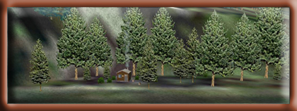 sleeping
space for 4 to 6 people. The cabin was built in 1967. sleeping
space for 4 to 6 people. The cabin was built in 1967.
Location: Approximately 33 air miles (53 km) northeast
of Ketchikan on the mainland east of Winstanley Island, elevation
400 feet (122 m). It is accessible by float plane or canoe. In
fall, winter and early spring, the cabin may be inaccessible
due to the frozen lake surface (float planes cannot land). Access
by canoe involves a 2.5 mile (4 km) hike from salt water plus
a 2.5 mile (4 km) paddle to the cabin. A mooring buoy is located
at trailhead. This cabin is located within the Misty Fiords National
Monument Wilderness. Please Leave No Trace of your visit.
Season of Use: Year-around.
Facilities: 2 single plywood bunks, 2 double plywood
bunks, Table and benches, Wood stove, Cooking counter, Food cupboard
and shelves, Broom, mop and bucket, Outhouse toilet. Axe, Maul
and wedge,14' aluminum skiff with oars and NO life jackets
Water is available from the lake. Treat all water before
using. Bring your own sleeping bags, sleeping pads, cooking stove,
lantern, pots, pans, plates, utensils, food, toilet paper, garbage
bags, fire extinguisher and fire starter. This cabin contains
a wood stove. Please conserve firewood; supplied firewood is
for wood stove use only.
Special Features: Recreation opportunities abound at
this cabin. The cabin location offers scenic views, access to
fishing and hunting, quiet solitude, and just relaxation. For
the more adventurous at heart, a paddle down to the outlet will
lead you to the historic Winstanley Lake Shelter constructed
by the CCC back in the early 1930s. From here a person can hike
to salt water on the Winstanley Lake Trail (#743). Fishing includes
cutthroat and kokanee. Hunting for mountain goat, Sitka blacktail
deer, black bear, and brown bear all occurs in this area. Keep
your eyes open for mink, marten, beaver, and otter.
Back to Index or Back
to Top
|
Comments to Doug
Hope you enjoyed the flight. If you have any questions
or comments, you can contact me at contact@mistymoorings.com.

I would like to personally thank the United States Forestry Service
for the information that helped make this document possible. Most
of the information came directly from their websites and each website
that we quoted is documented in the cabins sections by the cabin
name. The "notes" section, below are active links directly
to the US Forestry Service web pages. There is a great deal more
information about the cabins on the US Forestry Service websites
and you are encouraged to visit these sites to learn more about
these unique cabins. Also, after flying virtually around Misty
Fjords, you may suddenly have a desire to get out your 30.06 rifle,
your sleeping bag, a few cans of beans and head for Misty Fjords
and the cabins. If such a thought overcomes you, the links below
will help you with reservations.
Again, our sincere thanks to the US Forestry Service ... not just
for the information, but also for the wonderful cabins.
Note 1: Tongass National Forest [ http://www.vacationalaska.com/info/publiclands/Cab_Resinfo_Tongass.html ]
Note 2: Red Alders Cabin [ http://www.fs.fed.us/r10/tongass/recreation/rec_facilities/ktncabins/redalders.html ]
Note 3: Ella Narrows Cabin [http://www.fs.fed.us/r10/tongass/recreation/rec_facilities/ktncabins/ellanarrows.html ]
Note 4: Alava Bay Cabin [ http://www.fs.fed.us/r10/tongass/cabins/ketchikan/alavabay.shtml ]
Note 5: Winstanley Lake Cabin [ http://www.fs.fed.us/r10/tongass/recreation/rec_facilities/ktncabins/winstanlk.html ]
Note 6: Winstanley Island Cabin [ http://www.fs.fed.us/r10/tongass/recreation/rec_facilities/ktncabins/winstanley.html ]
Note 7: Wilson Narrows Cabin [ http://www.fs.fed.us/r10/tongass/cabins/ketchikan/wilsonnarrows.shtml ]
Note 8: Wilson Lake View Cabin [ http://www.fs.fed.us/r10/tongass/recreation/rec_facilities/ktncabins/wilsonview.html ]
Note 9: Bakewell Lake Cabin [ http://www.fs.fed.us/r10/tongass/recreation/rec_facilities/ktncabins/bakewelllk.html ]
Note 10: Beaver Lake Cabin [ http://www.fs.fed.us/r10/tongass/cabins/ketchikan/beaver.shtml ]
Note 11: Big Goat Lake Cabin [ http://www.fs.fed.us/r10/tongass/recreation/rec_facilities/ktncabins/biggoatlk.html ]
Note 12: Checats Lake Cabin [ http://www.fs.fed.us/r10/tongass/recreation/rec_facilities/ktncabins/checatslk.html ]
Note 13: Hugh Smith Lake Cabin [ http://www.fs.fed.us/r10/tongass/recreation/rec_facilities/ktncabins/hughsmith.html ]
Note 14: Humpback Lake Cabin [ http://www.fs.fed.us/r10/tongass/recreation/rec_facilities/ktncabins/humpbacklk.html ]
Note 15: Manzanita Lake Cabin [ http://www.fs.fed.us/r10/tongass/recreation/rec_facilities/ktncabins/manzanita.html ]
Note 16: Kegan Cove Cabin [ http://www.fs.fed.us/r10/tongass/cabins/pow/kegancove.shtml ]
Note 17: Rainbow Lake Cabin [ http://www.fs.fed.us/r10/tongass/recreation/rec_facilities/ktncabins/rainbowlk.html ]
Note 18: McDonald Lake Cabin [ http://www.fs.fed.us/r10/tongass/recreation/rec_facilities/ktncabins/mcdonaldlk.html ]
Back to Index or Back
to Top
|
Document Information
|
| Created: |
December 12, 2004 |
| Updated: |
October 01, 2006 |
Return to the Misty
Moorings Home Page |
|