|
Route Notes:
- Minimum altitude: Runway is at 2400 feet elevation.
- Direct Routing: Not applicable
- Landing zone:Water and hard runway. Water can freeze in winter.
- Scenery needed: Last Chance Lake from Misty Moorings
- Click [here] for printer-friendly
TripTic
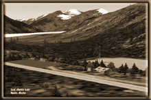
Last Chance Lake
A short flight from Stewart, BC up among the glaciers of Misty
Fjords. For the "off-roaders" ... this is a paradise for
four wheel drive vehicles. Fly up to Last Chance Lake and rent a
Jeep from Doug's Jeep Rentals and trek among the glaciers. There
is a fine map outside the lodging that will tell you where the glaciers
are located. For those with courage, it is possible (with a winch
(occasional slew) to drive from Stewart all the way up to Last Chance.
It takes about 2 hours (easier to fly!).
TreeTop VFR Plan
From: Stewart, BC
To: Last Chance Lake
1. Start your flight at Stewart, BC flying a heading of 180
out out over the Portland Canal and watching for the Salmon River
to starboard.
... Fly over the breakwater from Stewart BC
... About 1 mile out into the Portland Canal you will see a peninsula
on your right with a long shipping dock coming out from the land.
... That little town on the peninsula is Hyder, Alaska (notice you
are crossing the US/Canadian border right here).
... The river coming down between the mountains to starboard is
the Salmon River. This is one of the finest fishing rivers in the
world, and known for the beautiful fish that are taken from here
each year.
... be ready to round that peninsula making a turn to starboard.
2. Turn to starboard to about 310 into the mouth of the Salmon
River.
... You are going to be following both the river and the road as
you fly up to Last Chance Lake.
... Follow the winding river up between the mountains.
... This river is actually melt water from the Salmon Glacier up
about 3000 feet.
... As we get higher, you will be able to see the foot of the glacier
ahead.
... watch the road and the river closely and you will see they branch
after about 10 miles. You will be taking the branch to the left
(look closely ahead and you will see the foot of the Salmon Glacier
about 2 mile ahead).
3. When the road branches to the left, follow it up between
the mountains them up the valley at a heading of about 225 for about
eight miles.
... when you see the road going to the left, it looks like it is
going through a valley about 11 o'clock. But look closely and you'll
see the road loop back toward you then climb up the side of a mountain.
The valley you are going to go up is actually at about 9 o'clock.
Watch the road carefully.
... you should begin your climb as you head toward the summit.
... as you reach the summit, you will see the Last Chance Lake complex,
the lake, runway, lodging, and Jeep rental offices. You will be
almost lined up on the runway. When it starts coming into view,
get into landing configuration.
================================================================
To return to Stewart, follow the road back down the Salmon River,
turn to port over the Portland Canal and line up on the runway at
Stewart BC
Doug Linn
Charter Manager
Misty Moorings, Inc
contact@mistymoorings.com
|