|
Back to Charters
Office
VFR Flight
Misty Fjords - Through the Maze
(Misty Fjords Scenery Trip - Ketchikan to Stewart
through the Adams Range)
| |
Airfield |
ICAO Code |
Runway |
| Departure |
Ketchikan, AK |
PAKT |
At Ramp |
| Arrival |
Stewart, BC |
CZST |
At Ramp |
|
Charter Comments
When you take your first
trip to Alaska, you will have an opportunity to observe
the DHC-2 Beavers in action. Many flights for this area
are for the tourists arriving on the cruise ships docking
there. The flights are often short (1-2 hours) so people
can fully enjoy the experience but get back to the cruise
ship before it leaves. During these flights, the pilots
often tell wonderful stories about the fascinating scenery
you are seeing out the windows of the aircraft. There
is a great deal of history in Alaska and many stories
to tell (we think some of them are actually true!). Misty
Moorings Charters are created to give the 'tourist'
in us an opportunity to experience virtual Alaska making
it 'as real as it gets.' Just follow the FSNavigator fixes
and as you arrive at each of them, read the text that
explains what you are seeing out your windows. We hope
you enjoy the flights and enjoy the wonders of Alaska
[virtually] as though your were actually there.
If you are using FSNavigator4, and
your aircraft has an autopilot, all you will need to do
is takeoff and land along the way. The software will guide
you perfectly. There is also a plan (map) for this charter
that you can download here.
For this particular flight, to trust your autopilot completely,
you MUST be using the Misty Fjords scenery package. You
can also use the FS9 Flight Planner as it will also guide
you to the destinations. Both the FSNavigator (fsn) and
FS2004 Plan (pln) files can be downloaded here.
An altitude of 2600 feet will get you safely through the
mountains using these routes. However, it is more exciting
to fly at treetop levels with you controlling the altitude.
Also, if you have access to EZ-Landmark you may download
the Misty Fjords EZ-Landmark database here.
This file adds 400 landmarks that are exclusive for the
Misty Fjords scanty package.
Printer-Friendly Plan - Rather than
downloading this web page, you can download a 'Printer
Friendly Plan' to use for your flight. You may download
it [here].
|
|
|
The Flight
We are going to fly VFR from Ketchikan (PAKT) to 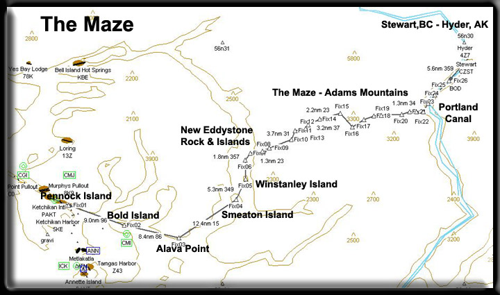 the
Stewart (CZST). It is quite easy to fly direct from Ketchikan to
Stewart, simply go to 3000 feet and set your heading for Stewart
(CZST) and fly there directly. But if you want to see this beautiful
area from tree top level, down inside the very heart of Misty Fjords,
then you will give yourself and any tourists on board a real thrill
by letting them experience Misty Fjords up "CLOSE." You
can set your autopilot on 2600 feet and have a safe flight, but
if you want a little more excitement, fly the treetops and the wave
tops. The details of the Misty Fjords scenery package are designed
for up close scrutiny. There are US Forestry cabins to spot, cruise
ships sailing down the channels, fishing boats in the coves, even
waterfalls and navigational buoys and markers. Our flight will take
us down the Tongass Narrows into the Revillagigedo Channel over
Bold Island and finally turning into the Behm Canal. We will fly
over Alava Bay, Smeaton and Winstanley islands before turning into
Rudyerd Bay. Here you will be flying into the heart of Misty Fjords
by following a mountainous maze through the Adam Mountains. You
will then emerging into the beautiful Portland Canal and on to the
scenic Stewart/Hyder area. the
Stewart (CZST). It is quite easy to fly direct from Ketchikan to
Stewart, simply go to 3000 feet and set your heading for Stewart
(CZST) and fly there directly. But if you want to see this beautiful
area from tree top level, down inside the very heart of Misty Fjords,
then you will give yourself and any tourists on board a real thrill
by letting them experience Misty Fjords up "CLOSE." You
can set your autopilot on 2600 feet and have a safe flight, but
if you want a little more excitement, fly the treetops and the wave
tops. The details of the Misty Fjords scenery package are designed
for up close scrutiny. There are US Forestry cabins to spot, cruise
ships sailing down the channels, fishing boats in the coves, even
waterfalls and navigational buoys and markers. Our flight will take
us down the Tongass Narrows into the Revillagigedo Channel over
Bold Island and finally turning into the Behm Canal. We will fly
over Alava Bay, Smeaton and Winstanley islands before turning into
Rudyerd Bay. Here you will be flying into the heart of Misty Fjords
by following a mountainous maze through the Adam Mountains. You
will then emerging into the beautiful Portland Canal and on to the
scenic Stewart/Hyder area.
Note: (You may click on the map to enlarge it for
printing).
At Ketchikan International PAKT
Our trip starts at Ketchikan International airport (PAKT). Be sure
to download the correct weather to get the full effect of flying
in Alaska. Do not be surprised if 8 out of 10 times, you will be
looking at rain and mist ... there is a reason they call this area
"Misty Fjords." Your flight will be VFR, but you can use
the FS2004 GPS in conjunction with the downloaded flight plans.
Keep an eye out for the cruise ships that ply these waters as well
as other commercial traffic, tugboats, ferryboats, towed barges,
etc. These features are all included in the Misty Fjords Scenery
package. The area we will fly through lies in the maritime climate
zone noted for its warm winters, cool summers, and heavy precipitation.
Average summer temperatures range from 46F to 59F; average winter
temperatures range from 29F to 48F. The record high temperature
is 97F; the record low is -4F.. Precipitation averages 163 inches
per year, including 69 inches of snow!
Ketchikan: Whether you arrive on a jet that
swoops in from Seattle, aboard an Alaska Marine Highway ferry, or
a cruise ship, you know you're in Alaska when you set foot in Ketchikan.
The little town of 14,500 is built right over the water in many
places—the steep hillsides make construction extremely expensive.
Established originally as a fishing camp, Ketchikan today bustles
with activity. Commercial fishing enterprises, growing tourism and
the Misty Fjords National Monument to the east make 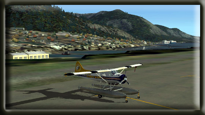 Ketchikan
a great place to visit. To see an outstanding collection of totems,
make a stop here. This is essential for anyone looking for the "real
Alaska". Ketchikan's name supposedly comes from the native
term "Katch Kanna", which roughly translates: "spread
wings of a prostrate eagle". But lest you think eagles are
creatures of the past, look carefully along the water line, both
north and south of town, and you're likely to see one or more bald
eagles circling back to their waterside perches. Although the town
appears to have grown in topsy-turvy fashion, it almost seems today
to have been built for its visitors: The big jet airport (its runways
built on three levels), is just a short ferry ride across Tongass
Narrows. In 1883, a man named Snow built a salmon saltery on the
spot where Ketchikan now stands. Two years later, businessmen from
Portland, Oregon, hired Mike Martin to investigate possibilities
for building a salmon cannery on the banks of Ketchikan Creek. Martin
and the cannery's manager, George Clark, set up a partnership and
opened a saltery and a general store. Two years later, with the
fishing trade flourishing, Ketchikan was definitely in business.
And by 1900, with a population of 800, the town was officially incorporated.
With mining activities beginning in the area, Ketchikan became an
important trading community, with an estimated two-thirds of miners'
wages reportedly ending up in the bars and bordellos of Creek Street.
Despite a mining decline, the fishing industry and timber operations
began to grow with establishment of the Ketchikan Spruce Mills early
in the century. The now closed Ketchikan Pulp mill can be seen in
Ward Cove. But despite some of these declines, industrious citizens
of Ketchikan are now geared up to deal with the emerging goldmine
of tourism. Cruise ships, the Alaska Marine Highway and Alaska Airlines
as well as many charter operators bring thousands of visitors to
town through the summer months, while across Tongass Narrows, an
endless stream of jet aircraft keep Ketchikan very much in touch
with the world outside. (See
Note 2) Ketchikan
a great place to visit. To see an outstanding collection of totems,
make a stop here. This is essential for anyone looking for the "real
Alaska". Ketchikan's name supposedly comes from the native
term "Katch Kanna", which roughly translates: "spread
wings of a prostrate eagle". But lest you think eagles are
creatures of the past, look carefully along the water line, both
north and south of town, and you're likely to see one or more bald
eagles circling back to their waterside perches. Although the town
appears to have grown in topsy-turvy fashion, it almost seems today
to have been built for its visitors: The big jet airport (its runways
built on three levels), is just a short ferry ride across Tongass
Narrows. In 1883, a man named Snow built a salmon saltery on the
spot where Ketchikan now stands. Two years later, businessmen from
Portland, Oregon, hired Mike Martin to investigate possibilities
for building a salmon cannery on the banks of Ketchikan Creek. Martin
and the cannery's manager, George Clark, set up a partnership and
opened a saltery and a general store. Two years later, with the
fishing trade flourishing, Ketchikan was definitely in business.
And by 1900, with a population of 800, the town was officially incorporated.
With mining activities beginning in the area, Ketchikan became an
important trading community, with an estimated two-thirds of miners'
wages reportedly ending up in the bars and bordellos of Creek Street.
Despite a mining decline, the fishing industry and timber operations
began to grow with establishment of the Ketchikan Spruce Mills early
in the century. The now closed Ketchikan Pulp mill can be seen in
Ward Cove. But despite some of these declines, industrious citizens
of Ketchikan are now geared up to deal with the emerging goldmine
of tourism. Cruise ships, the Alaska Marine Highway and Alaska Airlines
as well as many charter operators bring thousands of visitors to
town through the summer months, while across Tongass Narrows, an
endless stream of jet aircraft keep Ketchikan very much in touch
with the world outside. (See
Note 2)
A little about our destinations
...
Stewart and Hyder: Stewart's setting can only
be described in superlatives, combining an oceanfront location with
alpine scenery, glaciers, ice fields, and spectacular waterfalls.
This setting and the outdoor recreation opportunities it offers,
contribute in an important way to the communities lifestyles. The
area offers, fresh and saltwater fishing, boating, hiking, cross
country skiing, snowmobiling, and numerous other activities. Stewart's
colorful history has been dictated by the fortunes of the mining
industry. The first exploration in the area took place in the late
1890's and the town site was named in 1905. An estimated 10,000
people resided in the area in the early 1900's, attracted by the
prospects of gold; yet during World War I the population was reduced
to less than twenty. Stewart was founded by two Scottish brothers,
John and Robert Stewart. Major mines such as Premier Gold, Big Missouri
and Granduc Copper have been established in the Stewart area. These
projects created the impetus for population increases and attracted
a skilled work force to the community. Mining is also primarily
responsible for the development of support services such as heavy
duty mechanics, welding shops, and transportation-related businesses,
which provide service to all the basic resource industries. Today
employment in the community is much more broadly-based and includes
opportunities in transportation, mining, logging, retail and hospitality
sector, and public administration. As a contact zone between the
Coast Range Batholith and sedimentary formations to the east, the
Stewart area is highly mineralized and contains proven reserves
of a wide range of precious and base metals including gold, silver,
copper, lead and zinc. Hyder was originally called Portland city,
and the name was changed in 1914 after Frederick Hyder, a Canadian
mining engineer who predicted a bright future for the area. Hyder's
boom years occurred between the years 1920 and 1930, and the Riverside
Mine extracted gold, silver, copper, lead, zinc and tungsten until
1953. By 1956, all major mining had closed except for Granduc Copper
Mine in Canada, which operated until 1984. Hyder is known as the
"Friendliest Ghost Town in Alaska." Hyder's economy is
based primarily on tourism today. Visitors usually make more than
one visit to Fish Creek bear viewing area, trying to view grizzlies
and black bears as they feed on the spawning salmon. Continuing
on past Fish Creek visitors will re-enter Canada and begin their
assent to the Salmon Glacier. There are two public boat launching
facilities to the Portland Canal one located in Stewart and one
in Hyder. (See
Note 1)Your first sight of Hyder and Stewart will be from the
air and it is probably a site you will never forget. At the head
of the Portland Canal, these two small towns are nestled in among
the mountains, rivers, waterfalls and a lush forest. Keep your camera
handy, but you won't need to aim it ... every shot, in ever direction
will make a perfect picture. Let's get started.
|
|
Commentary
Fix 1 - The Tongass Narrows, Pennock Island and Saxman
When leaving PAKT position yourself to fly safely south down
the Tongass Narrows and fly to the center of Pennock Island. 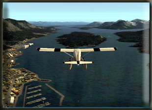 Once
over Pennock Island, set a course of 090 to head toward Bold Island,
6 miles ahead. Saxman is the small town beside Pennock Island located
on the west side of Revillagigedo Island, 2 miles south of Ketchikan
on the South Tongass Highway. In 1886, Tlingits from the old villages
of Tongass and Cape Fox wanted a new site to construct a central
BIA school and Presbyterian Church. The village subsequently was
named for Samuel Saxman, a Presbyterian teacher who was lost at
sea with a Cape Fox elder while searching for the new site. By 1894,
the new village site was chosen, ideally located on a protected
harbor off the Tongass Narrows. A small sawmill was built and construction
of the school and houses began immediately. Fishing and cutting
lumber for the growing towns of Saxman and Ketchikan were the economic
mainstays of the new village. By 1900, 142 people were living in
Saxman. In 1929, the community incorporated as a City. During the
1930s, many totem poles and ceremonial artifacts, such as carvings
and masks, were retrieved by the Civilian Conservation Corps from
the abandoned villages at Cape Fox, Tongass, Cat Island and Pennock
Island. Totem poles were restored and relocated to Saxman as part
of a U.S. Forest Service program. A rail-barge terminal at the Saxman
Seaport was completed in 1967; it serves as the Ketchikan's major
cargo container terminal. A federally recognized tribe is located
in the community -- the Organized Village of Saxman. 70.1% of the
population are Alaska Native or part Native. Most residents are
Tlingit and lead a subsistence lifestyle. A recently-developed totem
pole carving center is fostering traditional skills and providing
tourism opportunities. (See
Note 3) Once
over Pennock Island, set a course of 090 to head toward Bold Island,
6 miles ahead. Saxman is the small town beside Pennock Island located
on the west side of Revillagigedo Island, 2 miles south of Ketchikan
on the South Tongass Highway. In 1886, Tlingits from the old villages
of Tongass and Cape Fox wanted a new site to construct a central
BIA school and Presbyterian Church. The village subsequently was
named for Samuel Saxman, a Presbyterian teacher who was lost at
sea with a Cape Fox elder while searching for the new site. By 1894,
the new village site was chosen, ideally located on a protected
harbor off the Tongass Narrows. A small sawmill was built and construction
of the school and houses began immediately. Fishing and cutting
lumber for the growing towns of Saxman and Ketchikan were the economic
mainstays of the new village. By 1900, 142 people were living in
Saxman. In 1929, the community incorporated as a City. During the
1930s, many totem poles and ceremonial artifacts, such as carvings
and masks, were retrieved by the Civilian Conservation Corps from
the abandoned villages at Cape Fox, Tongass, Cat Island and Pennock
Island. Totem poles were restored and relocated to Saxman as part
of a U.S. Forest Service program. A rail-barge terminal at the Saxman
Seaport was completed in 1967; it serves as the Ketchikan's major
cargo container terminal. A federally recognized tribe is located
in the community -- the Organized Village of Saxman. 70.1% of the
population are Alaska Native or part Native. Most residents are
Tlingit and lead a subsistence lifestyle. A recently-developed totem
pole carving center is fostering traditional skills and providing
tourism opportunities. (See
Note 3)
Fix 2 - Bold Island
On the way to Bold Island, you will pass by Mountain Point on your
left. The mountain to your right is Red Mountain and at its northern
point where it meets the sea is the little community of China Town.
It is interesting to note that China did a large trade in sea otter
furs with the previous owner of Alaska, Russia. You will find many
references to China in the area. To your right Annette Bay the body
of water that is nestled between Red Mountain and the peninsula
coming up on your right. The tip of the peninsula is Race Point.
The large inlet to your left is Carrol Inlet which extends about
20 miles, part of it coming up behind Ketchikan. The small island
showing up along your course just to the right is Spire Island.
The large island ahead of you is Bold Island, our next waypoint.
Once you are over the center of Bold Island, set a course Alava
Point at a heading of 086, about 7 miles ahead.
Fix 3 - Alava Point
As you make your turn for Alava Point, you are passing the 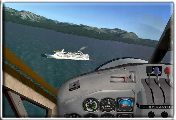 Thorne
Arm to port. On the left point you will find Coho Cove complete
with a small (virtual) settlement called Antelope Trail Ranch. (This
is unique scenery in the Misty Fjords Scenery package). At the ranch,
you will find a dirt runway, a Hangar for your plane, and down in
Coho Cove a float plane Hangar and dock. On the right side of this
inlet is Cone Island and Cone Point that define the southern entrance
to the Thorne Arm. The point straight ahead of you is Alava Point.
Once you arrive at Alva Point, set your course for 014 heading toward
your next waypoint at Smeaton Island, 12.4 miles ahead. Thorne
Arm to port. On the left point you will find Coho Cove complete
with a small (virtual) settlement called Antelope Trail Ranch. (This
is unique scenery in the Misty Fjords Scenery package). At the ranch,
you will find a dirt runway, a Hangar for your plane, and down in
Coho Cove a float plane Hangar and dock. On the right side of this
inlet is Cone Island and Cone Point that define the southern entrance
to the Thorne Arm. The point straight ahead of you is Alava Point.
Once you arrive at Alva Point, set your course for 014 heading toward
your next waypoint at Smeaton Island, 12.4 miles ahead.
Fix 4 - Smeaton Island
As you fly this leg, you have turned into the Behm Canal. This
unique waterway completely circles the Ketchikan area. You will
be flying directly over Alava Bay and will have your first chance
to try to spot one of the famous US Forestry Misty Fjords cabins.
Look closely and you will see it on the north side of large island
in the center of Alava bay. (These cabins are visible in the Misty
Fjords Scenery package). Look for a wisp of smoke from the chimney
or the campfires usually burning in front of the cabin. Here's some
information about this particular cabin and also some information
on how the cabins are used.
M-01, Alava Bay Cabin: (See
Note 6) Access is by air and is approximately 20 miles southeast
of Ketchikan. Other access is by boat approximately 1 1/2 hours
travel time; mooring buoy is near by. Water is available from a
stream nearby. Wildlife includes black bear and Sitka black tailed
deer which may be hunted during regulated seasons. You can fish
for saltwater species and in a nearby stream for Dolly Varden and
cutthroat trout.
The US Forest Service Cabins - Information: (See
Note 7)
Reservations: Reservations may be made up to 180 days
(6-months) in advance of intended use. Applications will not be
accepted more than 190 days prior to desired occupancy. Applications
received earlier than this will be promptly returned with an explanation.
If more than one application is is received between 180 and 190
days in advance of intended use for a cabin for overlapping dates,
a drawing will be held to determine the permittee. Payments will
be returned to unsuccessful applicants. Confirmed reservations
may be made up to 179 days in advance of intended use on a first-come,
first-served basis. Permittees must be at least 18 years old.
Any number of persons can occupy a cabin under a single permit.
The maximum stay at a cabin is (7) seven nights between April
1 and October 31, and (10) ten nights between November 1 and March
31. The advance payment is refundable upon written request, and
return of the original permit, if it is received in the office
from which the permit was issued from 10 days prior to intended
use. Cabins are reserved from noon to noon.
Cabin Facilities: The two most common types of cabins
are A-Frames and Pan-Abode. Each can sleep at least four to six
people.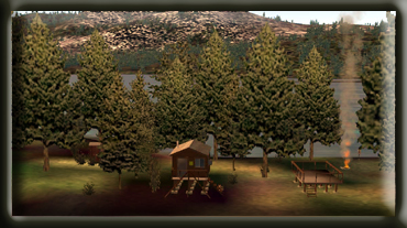 A-Frame cabins have an additional second floor sleeping loft.
Each cabin includes tables, benches, plywood bunks (without mattresses),
wood or oil heating/cooking stoves, axe/maul, broom, and pit toilets.
A-Frame cabins have an additional second floor sleeping loft.
Each cabin includes tables, benches, plywood bunks (without mattresses),
wood or oil heating/cooking stoves, axe/maul, broom, and pit toilets.
Water: Water can be taken from nearby streams or lakes
and should be boiled or treated before drinking. Although many
of the rivers and steams appear crystal clear and give the impression
that the water is pure, clarity is not an indication of the absence
of bacteria or parasites. Whenever surface water is used for drinking
or cooking, it should be treated or boiled for 5 minutes to avoid
contracting giardiasis or other diseases. Giardiasis is an intestinal
disorder which can be contracted from drinking untreated "natural"
water.
Equipment: You must bring your own bedding and cooking
gear. Be sure to check the specific stove information for the
cabin you desire. The Forest Service does not provide stove oil
for cabin users. Oil can be purchased in the local communities.
It MUST be #1 diesel oil for the stove to operate properly. Oil
use varies from 5-10 gallons per week depending on the time of
year and the weather. At cabins with wood stove, wood may be provided
but must be split. Check with the Forest Service office administering
the cabin for information on wood availability. An axe or maul
is provided at cabins with a wood stove, but you should bring
a small axe or hatchet just in case the tools at the cabin are
not there. In all cabins it is recommended that a cooking stove
be included in your gear. The wood/oil stoves do not usually provide
sufficient heat for cooking.
Trail Information Sheets: At cabins where trail access
is possible or where trails are mentioned; request a trail information
sheet from the Forest Service office administering the cabin.
Safety: In the "old-days" thorough preparation
and caution, using simple equipment and common sense, was a natural
part of living and working in the wilderness of Southeast Alaska.
Since then, conditions have changed little. Safety is still a
matter of individual responsibility and is based on thorough knowledge
of what to expect, the right equipment and common sense. Rain
gear, rubber boots and warm clothing are essential. Extra food
and clothing are recommended, as your stay could be prolonged
by bad weather or poor visibility for travel. In remote locations,
remember you are on your own! We recommend topographical maps,
compass, waterproof matches, strong knife, first-aid kit, space
blanket, small tent or emergency shelter, extra food, candles,
and flares. For those experienced with firearms, a gun (30.06
or larger caliber) can be taken for unexpected emergencies.
Bears: Remember that you are in bear country. Burn
trash, or dispose of it so that bears are not attracted. Keep
food items neat and clean to cut down on odors which may attract
bears. Warn bears of your presence by making noise when in dense
cover. "Bear Facts", a pamphlet on bear safety, is available
from the Forest Service.
Shellfish: Clam diggers should be cautious of Paralytic
Shellfish Poisoning (PSP), PSP is an extremely poisonous toxin
found in clams, mussels, geoducks, oysters, snails, and surface
scallops. PSP can kill you--be careful where you clam. The brochure
"PSP What you should know before you go clamming" is
available from the Forest Service.
Pack It In - Pack It Out: Maintenance of Forest
Service cabins is very costly. To reduce these costs and the possibility
of bear and rodent problems, all garbage and leftover food from
your stay MUST be packed out. It is hoped that you will leave
the cabin in the same condition or better than you found it. Leave
a clean cabin so the next user will also enjoy their stay.
Marine Mooring Buoys: Buoys are strategically placed
to facilitate the anchorage of small boats in interesting areas
otherwise unavailable due to a lack of good anchor "holding
ground". A reservation at a Forest Service cabin does not
include exclusive use of the buoy if one is located near the cabin.
Buoys are on a first-come first-serve basis. Rafting of more than
one vessel is permitted with the agreement of each vessel owner.
Three vessels that are less than 21 feet or two vessels between
21 and 30 feet are allowed to tie up to an anchor buoy. Do not
anchor vessels over 30 feet on mooring buoys. PLEASE limit moorage
to 36 hours.
Still want to try a cabin? Imagine the kinds of gear you'll be
storing on board your aircraft taking people to these cabins ...
axes, 30.06 rifles, #1 diesel oil? Could be an interesting trip!
We will watch for more cabins along the way. Your course is now
taking you over the small Rudyerd Island. When you fly over Rudyerd
Island, Smeaton Island will be 4 miles ahead. We are continuing
to fly up the Behm Canal. To the right of our course is Nelson Point
and to the left of Smeaton Island is Princess Bay. Once over Smeaton
Island, set your heading to 353 so you will fly toward Winstanley
Island the long island about 5.3 miles ahead of you.
Fix 5 - Winstanley Island
As we fly toward Winstanley, here are a few facts about it the
Misty Fjords National Monument we will be flying into. The 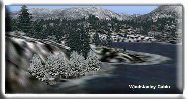 Misty
Fjords National Monument includes 2,294,343 acres on the southern
tip of the Alaska Panhandle, all but about 156,000 acres near the
middle have been designated Wilderness. Misty Fjords is part of
a vast coastal rain forest and the cloud-shrouded monument can receive
160 inches of rain annually. The region is marked by deep valleys
with steep slopes and sharp inter-valley ridges formed by volcanism
and carved by glaciation. The slopes appear to be an unbroken carpet
of cedar, spruce and hemlock, but the forest floor stands open at
numerous muskegs dominated by sphagnum moss. Ridges rise above the
timberline to alpine heaths and grasses. Numerous steep-walled inlets
of the sea called fjords offer excellent sea-kayaking opportunities,
although 25-foot changes in the tides and frequent storms can make
boating challenging. Ideal beach camps may be underwater two hours
after pitching a tent. Behm Canal that we are currently flying over
is the longest waterway into the Wilderness, runs for over 100 miles
and old lava flows and extensive glaciers add to the wonder. As
we mentioned previously, Tongass National Forest maintains 15 recreational
cabins, 12 are on inland freshwater lakes and 3 on saltwater. One
of the saltwater cabins will pass under us at the north end of Winstanley
Island. The Winstanley Island Cabin is located 30 miles slightly
north east of Ketchikan on East Behm Canal between Rudyerd Bay and
Smeaton Bay. The cabin is on the north end of Winstanley Island
facing Shoalwater Pass. The cabin is both accessible by air and
water. Watercraft travel takes approximately 3 hours. Drinking water
is available from a nearby stream. Several hunting areas are available
by boat. The cabin is available all year long. (See
Note 6)Over Winstanley Island, set a heading of 340 and this
heading will take us over the tiny New Eddystone Islands. You will
begin to see the entrance of Rudyerd Bay coming up on your starboard
at about 2 o'clock. Misty
Fjords National Monument includes 2,294,343 acres on the southern
tip of the Alaska Panhandle, all but about 156,000 acres near the
middle have been designated Wilderness. Misty Fjords is part of
a vast coastal rain forest and the cloud-shrouded monument can receive
160 inches of rain annually. The region is marked by deep valleys
with steep slopes and sharp inter-valley ridges formed by volcanism
and carved by glaciation. The slopes appear to be an unbroken carpet
of cedar, spruce and hemlock, but the forest floor stands open at
numerous muskegs dominated by sphagnum moss. Ridges rise above the
timberline to alpine heaths and grasses. Numerous steep-walled inlets
of the sea called fjords offer excellent sea-kayaking opportunities,
although 25-foot changes in the tides and frequent storms can make
boating challenging. Ideal beach camps may be underwater two hours
after pitching a tent. Behm Canal that we are currently flying over
is the longest waterway into the Wilderness, runs for over 100 miles
and old lava flows and extensive glaciers add to the wonder. As
we mentioned previously, Tongass National Forest maintains 15 recreational
cabins, 12 are on inland freshwater lakes and 3 on saltwater. One
of the saltwater cabins will pass under us at the north end of Winstanley
Island. The Winstanley Island Cabin is located 30 miles slightly
north east of Ketchikan on East Behm Canal between Rudyerd Bay and
Smeaton Bay. The cabin is on the north end of Winstanley Island
facing Shoalwater Pass. The cabin is both accessible by air and
water. Watercraft travel takes approximately 3 hours. Drinking water
is available from a nearby stream. Several hunting areas are available
by boat. The cabin is available all year long. (See
Note 6)Over Winstanley Island, set a heading of 340 and this
heading will take us over the tiny New Eddystone Islands. You will
begin to see the entrance of Rudyerd Bay coming up on your starboard
at about 2 o'clock.
Fix 6 - New Eddystone Islands
Once over the New Eddystone Islands, set your heading at 001 flying
to the center of the entrance of Rudyerd Bay rounding Louis Point.
This is the "entrance to the maze" we'll be flying for
the next 25 minutes. From this point on until we reach the Portland
Canal, we'll concentrating on the flying as the waypoints and flying
can be hazardous. We are going to fly into the heart of the Adams
Mountain range following river valleys to finally reach the Portland
Canal. There are some sharp turns and we'll have to pay close attention
and use all our flying skills to navigate this next part of the
leg safely.
Fix 7 - Entering Rudyerd Bay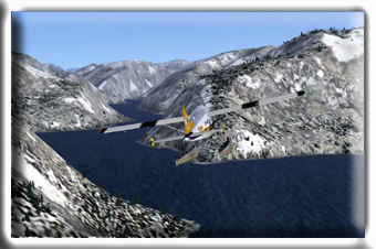 Rounding
Louise Point on our right, we will now fly into Rudyerd Bay. DO
NOT fly lower than 1700 feet in the maze! Here the bay branches
to the left and right. The right branch is Punchbowl Cove. Just
beyond Punchbowl Cove, over the small mountain, is the beautiful
Punchbowl Lake. We will be taking the left branch which is the continuation
of Rudyerd Bay. Rounding
Louise Point on our right, we will now fly into Rudyerd Bay. DO
NOT fly lower than 1700 feet in the maze! Here the bay branches
to the left and right. The right branch is Punchbowl Cove. Just
beyond Punchbowl Cove, over the small mountain, is the beautiful
Punchbowl Lake. We will be taking the left branch which is the continuation
of Rudyerd Bay.
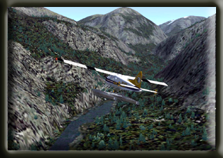
Fix 8-14 Following the Adams Mountain Maze
On these next fixes, we will be winding our way up Rudyerd Bay and
into the Adams Mountains. You will be seeing the very heart of the
Misty Fjords National Park, up dangerously close and exquisitely
beautiful. Be ready for a sharp starboard turn at fix 15, buckle
up, it is a white knuckle turn. You should be increasing your altitude
toward 2600 feet minimum.
Fix 15 - White Knuckle Curve
You will see a "Y" intersection ahead of us, we will
be taking the left branch. At this fix, we are going to take a sharp
turn to the right to head toward the Portland Canal which is on
the other side of the Adam Mountain range. If you have been flying
less than 2600 feet, this would be a wonderful time to make sure
you are increasing your altitude toward 2600 feet (check that barometer
one more time and make sure you have it set correctly ("B").
Fix 17 Continuing the Adams Mountains Maze
The highest point in this flight will be just beyond Fix 17. Make
sure you are at 2600 feet!
 Fix
20 - The Portland Canal Fix
20 - The Portland Canal
Here you get your first glimpse of the open beauty of the Portland
Canal. Once you clear the final peak, you may safely reduce altitude
to 1200 feet or to any altitude you like. The airport you will be
landing at is at sea level and you'll be headed right toward it..
At Fix 23 - Turning toward Stewart
Once into the Portland Canal, you can make a turn to 019 and begin
centering up on your final heading for Stewart.
At Fix 26 - Stewart Approach
We are now approaching the Stewart airport. As it comes into view,
on your left you will see the Salmon River winding down from the
glacier. The little community on the left is Hyder. Ahead of us
is the community of Stewart and our destination, Stewart airport
(CZST).
Visiting Stewart and Hyder - Things to know, see and do.
To learn more about Stewart, BC you should visit the website
of http://www.stewartbc.com/.
This website has the history, folklore stories about the area. It
is a must read if you would like to know more about this area. Situated
at the end of the Portland Canal and across from Alaska's Misty
Fjords National park, Stewart is a unique border town attracting
as many American tourists as Canadian. Important to the economy
are the industries of forestry and mining - the main employers in
the town. The community is promoting the development of a wood processor
and is endeavoring to cultivate bulk cargo for its port. You should
try to visit the famous Bear Glacier, one of the few blue glaciers
with the easiest access in the world. Also, take a walk on one of
the hiking trails that reveal the evidence of old gold and silver
mines as they take one on a walk through the magnificent coastal
forest, mountain streams and alpine meadows. Be sure to try the
amazing fishing in the numerous streams and lakes. You can watch
the spawning of the rare Alaskan Chum Salmon at Fish Creek. If saltwater
fishing is your thing, make sure to take a boat ride on the Portland
Canal to catch prawns and crabs...or maybe see a majestic killer
whale. Don't miss out on the spectacular drive from Stewart to Hyder
and follow the road through the Salmon River valley right up to
the old Granduc mine along the Berendon Glacier. Keep your eye out
for the spectacular view of Salmon Glacier, it is the fifth largest
glacier in the world. You can easily take your car or RV on this
road, but if you wish, there are some fun tours as well. Stewart,
BC is a small town big in history, nature and beauty. Mining was
Stewart's beginning when 68 prospectors came to the head of the
Portland Canal in the spring of 1898 looking for placer gold. Although
rumors said the deposits equaled those of the Klondike, the promised
"poor man" placer never materialized. However, other gold
camps, once attention had been drawn to the area, mining and exploration
increased. Stewart is on the Cassiar Highway at the head of the
Portland Canal, a narrow saltwater fjord 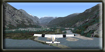 approximately
90 miles/145 kilometers long. The fjord forms a natural boundary
between Alaska and Canada. Stewart has a deep harbour and boasts
of being "Canada's Most Northerly Ice Free Port". Prior
to the coming of the white man, Nass River Indians knew the head
of the Portland Canal as Skam-A-Kounst, meaning safe place, referring
to the place as a retreat from the harassment of the coastal Hiadas.
The Nass came here annually to hunt birds and pick berries. Little
evidence of their presence remains today. approximately
90 miles/145 kilometers long. The fjord forms a natural boundary
between Alaska and Canada. Stewart has a deep harbour and boasts
of being "Canada's Most Northerly Ice Free Port". Prior
to the coming of the white man, Nass River Indians knew the head
of the Portland Canal as Skam-A-Kounst, meaning safe place, referring
to the place as a retreat from the harassment of the coastal Hiadas.
The Nass came here annually to hunt birds and pick berries. Little
evidence of their presence remains today.
In 1896, Captain D. Gillard (after whom the Gillard Cut in the Portland
Canal was later named) explored the Portland Canal for the U.S.
Army Corps of Engineers. Two years after Gillards visit, the first
prospectors and settlers arrived. Among them was D. J. Raine, for
whom a creek and a mountain in the area are named. The Stewart brothers
arrived in 1902, and in 1905, Robert M. Stewart, the first postmaster,
named the town Stewart. Hyder was first called Portland City. It
was renamed Hyder, after Canadian mining engineer Frederick B. Hyder,
when the US Postal Authority told residents there were already too
many cities named Portland. Gold and silver mining dominated the
early economy. Hyder boomed with the discovery of rich silver veins
in the upper Salmon River basin in 1917-1918. Hundreds of pilings,
which supported structures during this boom period, are visible
in the tidal flats at Hyder and Stewart. Despite the many changes
in population from a high of 10,000 prior to the first world war,
to a low of under 700 today, Stewart has always and will continue
to persevere. (See
Note 4) (See
Note 5).
We hope you enjoyed the trip. Be sure to check back at Misty
Moorings, Inc. for more flights in this beautiful area of the
world.
|
|