|
Route Notes:
- Minimum altitude: no minimum ... suggested 1200 feet.
- Direct Routing: If the weather is favorable, you may fly a heading
from Mountain Point of 049 for 29 miles.
- Landing zone:hard runway, water nearby, freezes in winter
- Fuel: Fuel is available, turn off engine beside drums.
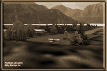
- Scenery: Punchbowl Lake Cabins from Misty Moorings
- Click [here] for printer-friendly
TripTic
Punchbowl Lake Cabins
Punchbowl Lake actually looks like a punchbowl, a pretty lake ringed
by mountains. In the center of the lake is a little island, and
it is upon this tiny island you will find the Punchbowl Lake Cabins
complex. There are several cabins, a hard runway, a parking area
and fuel is available.
TreeTop VFR Plan
From: Ketchikan International
To: Punchbowl Lake Cabins
1. After leaving PAKT or 5KE, position over Pennock Island in
the Tongass Narrows at a heading of 110
... As you approach Pennock Island, look to port to see the town
of Ketchikan, busy in the summertime with all the tourists, almost
abandoned in the wintertime.
... A little further down the coast on the port side you will see
the US Coast Guard Station with a NOAA ship tied up there.
2. At the south end of Pennock Island, head toward Bold Island,
Set your heading at 094. Bold Island is 9 miles ahead. [5.4 minutes]
... As you make your turn toward Bold Island, you see you will be
crossing the final point of land to port representing the end of
the Tongass Narrows and the beginning of the Revillagigado Channel
ahead.
... the point of land to the right is the southeastern most point
of Gravina Island (the island where PAKT is located). This is called
Gravina Point.
... The inlet to port that comes up is the Carol Inlet, a beautiful
20 mile long inlet that curves up behind Ketchikan.
... The peninsula jutting toward us from at 1 o'clock is Race Point,
a peninsula of land coming from Annette Island, the very large island
at 2 o'clock to starboard. The little bay formed by the peninsula
and the island is Annette Bay.
3. At the south end of Bold Island, set a heading for 088 for
Alava Point, the point of land 8.3 miles ahead. [5 minutes]
... As you cross Bold Island, look to the left to see Coho Cove
and look even closer and you may see the Antelope Trail Ranch complete
with runway and hangers for both land-based and floatplanes.
... The large island about 4 miles away at 2 o'clock is Ham Island,
look closely at it and you will see it gets its name from its shape.
The little island off its coast toward you is Walker Island.
4. At Alava Point set your heading at 019 for Smeaton Island,
9.6 miles ahead. You will fly over Rudyerd Island on this leg. [5.7
minutes]
... At this point, you are turning into the Behm Canal, a body of
water that circles the Ketchikan Area. Following this for about
120 miles will bring you right back to Ketchikan as it is a giant
circle.
... As we make the turn, we are first going to cross Alava Bay.
Look closely at the little islands and you may see a US Forestry
Service Cabin that is located on one of them.
... Next you will fly over Fox Point, a point of land coming from
the port shore of the Behm Canal.
... After Fox Point, look ahead to see Rudyerd Island that you will
cross on the way to Smeaton Island, the larger island beyond (and
your VFR waypoint).
NOTE: As you come to Smeaton Island, be sure you are flying
an altitude of at least 1200 feet.
5. At Smeaton Island, set your heading at 345 for Winstanley
Island, a large island on the starboard side of the Behm Canal about
5 miles ahead.
... Watch for tiny Candle Island that is just of the southern
shore of Winstanley Island.
...there is another US Forestry Service cabin that can be found
on the final cove on the starboard side of Winstanley Island.
6. Over Winstanley Island, set a course of 343 for Louise Point,
six miles ahead on the starboard shore. Louise Point is at the entrance
of Rudyerd Bay, a large inlet to starboard.
... Looking to starboard, you will see a waterfall coming from
Lower Checats Lake. If you look beyond this little lake you will
see the much larger Upper Checats Lake. There is a US Forestry Cabin
there also.
... the small islands we are crossing over are the New Eddystone
Islands and if you look to port out in the center of the Behm, you
will see the New Eddystone Rock.
... we will turn to starboard when we reach Louise Point into Rudyerd
Bay.
7. At Louise Point, turn into Rudyerd Bay coming to a heading
of about 059 degrees being ready to make a hard turn to starboard
into Punchbowl cove about a mile ahead.
... About one mile into Rudyerd Bay, you will come to an intersection,
Rudyerd Bay goes off to port, and Punchbowl cove to starboard.
8. Turn to starboard into Punchbowl cove coming to a heading
of about 118. Make sure your altitude is a minimum of 1200 feet.
Aim to fly over the ridge at the end of the cove at about 11 o'clock.
... Punchbowl Lake will come into view as you pass the last ridge
to port. It will be on a heading of about 090, turn toward it.
... drop altitude down toward the lake.
... there is a ridge coming out into the lake from starboard, fly
around that ridge and you will be lined up on the Punchbowl Lake
Cabins complex.
Note: Fuel is available at the complex. Pull up beside the fuel
barrels and turn off your engine, your tanks will be filled automatically.
===============================================================
To return to Ketchikan, reverse the route. If the weather is
permitting, the direct heading to Mountain Point is 219 for 29 miles.
Doug Linn
Charter Manager
Misty Moorings, Inc.
contact@mistymoorings.com
|