|
Route Notes:
- Minimum altitude: Landing zone altitude 500 feet ... suggested
trasit altitude 1000 feet.
- Direct Routing: If the weather is favorable, from Mountain Point
fly 010 for 25 miles.
- Landing zone: water, water can freeze in winter
- Snowy Own Fish Camp scenery needed from Misty Moorings
- Click [here] for printer-friendly
TripTic
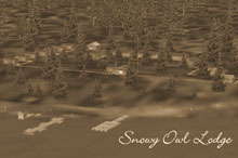
Snowy Owl Fish Camp
Welcome to SNOWY OWL Fish Camp! Snowy Owl is located 28 NM from
PAKT on a heading of 28*. This is a full service camp. There is
a main lodge for meals and for sitting around the fire telling all
those great "got away" stories. There is a laundry facility
here as well for those who will be staying with us for extended
periods of time. Loc (N55 38.50 w131 04.28)
TreeTop VFR Plan
From: Ketchikan International
To: Snowy Owl Fish Camp
1. Fly a heading of 100 down the Tongass Narrows toward Pennock
Island
...Fly over the center of Pennock Island
...watch for the cruise ships on left and the Clione vessel plying
the narrows.
...You'll pass Ketchikan on your left and see Saxman coming up on
your left as you fly over Pennock Island.
...Coming up on your right is Gravina Point.
2. Over Pennock Island, set a heading of 095 shooting the gap
between Mountain point on your left and Race Point on your right.
...You are now heading directly for Bold Island
...As we fly, you will be passing the entrance to the the Carol Inlet
on your left, it winds up behind Ketchikan, but is eventually a
dead end.
...Small Spire Island comes up to starboard
...Just past Spire Island the point of land is Reef Point. You should
be heading for the center of Bold Island, just ahead.
3. Over Bold Island, maintain a course of 095, you are
heading for Alava Point about 8 miles ahead.
...look closely and you will see the small Antellope Trail Ranch down
to your left there in Coho Cove.
...To our left is the inlet to the Thorne Arm.
...You are flying down the Revillagigedo Channel ( the gateway to
Alaska from the south). Wach for cruise ships in this area.
...Continue to Alava Point, we will be rounding it to the left starting
to fly up the Behm Canal.
4. Once you have just cleared the point, make a left turn
to 010 setting a visual heading for the left shore far in the distance
...We are getting ready to fly over Alava Bay, look closely at the
large island and you may see the Alava Bay Cabin
...The first point you encounter after Alava Bay is Ape Point
...The next point justting into the Behm Canal from the left shore
is Fox Point ... head to fly over Fox Point.
...continuing on this heading (095) you will see Rudyerd Island
coming up, visually head to fly over it.
...just beyond Rudyerd Island is Smeaton Island. Head for the center
of Smeaton Island, maintain minimum of 1200 feet.
...off to the right of Smeaton Island you'll see Smeaton Bay on
the starboard side of the canal.
... the leading edge of Smeaton Island is called Harris point ...
recheck your altitude for minimum 1200.
5. As you reach the far shore of Smeaton Island, make
a heading correction, turn left to 335 over Eddystone Rock.
...the northern point of Smeaton Island should come under your port
wing, that is Harding Point.
...off to starboard (your right) you will see little Candle Island,
then just beyond it the beautiful Winstanley Island
...there are two cabins on Winstanley Island.
... you may want to drop down to 300 feet to get a good look at
Eddystone Rock, a strange rock structure in the center of the Behm
Canal.
6. Over Eddystone Rock, continue heading of 335 flying toward
Manzanita Island, 4 miles ahead.
...You will see it appearing like a penninsula from the port side
of the Behm Canal.
7. Over Manzinita Island, set a heading of 320 following the
port shoreline toward Snip Island ready for a turn to port at the
outlet of Grace Creek.
... don't get too close in foggy weather as there are mountains
near the shore.
... The outfall from Grace Creek is a sharp little "bight"
or cove along the port shore. You will know you are close when you
see Snip Island about 1 mile away.
8. At the outlet from Grace Creek, turn to port to 225. Follow
this heading for 4.3 miles to Grace Lake.
... Over the lake, you will pass over a small peninsula coming from
the port side of the lake.
... The fish camp is about half way down the lake from the peninsula
on the starboard side.
===============================================================
To Return to Ketchikan, Reverse the above Route or, weather
permitting, fly a direct heading of 190 for 26 miles to Mountain
Point.
Doug Linn
Charter Manager
Misty Moorings, Inc
contact@mistymoorings.com
|